Weekend improvement, fun early next week
Western Australia Surf Forecast by Craig Brokensha (issued Friday August 13th)
Best Days: Saturday, Sunday and Monday all locations, Tuesday morning, Wednesday morning
Features of the Forecast (tl;dr)
- Easing swell Sat with variable winds and weak sea breezes
- Good mod-large W/SW-SW swell Sun with E morning winds ahead of late sea breezes
- Reinforcing, less consistent W/SW groundswell Mon AM with mod-fresh E/NE tending variable winds, easing Tue with S/SE tending S/SW winds
- New SW swell building Tue PM, easing Wed with variable morning winds
- Return to windy, onshore surf late next week
Recap
Great surf across Mandurah and Perth yesterday with clean conditions and surf to 3ft+ on the former, 3ft in Perth. The South West was large but onshore, improving into the afternoon as winds abated.
Today we saw a window of cleaner, lumpy conditions across the South West with 6ft+ sets, deteriorating through the day with a strengthening N'ly. Mandurah was a great, peaky 2-3ft and Perth 2ft. A reinforcing mid-period SW swell has kept wave heights up and steady all day.
This weekend and next week (Aug 14 - 20)
Looking at the weekend ahead and we've got a further improvement on the cards for the South West as the trough linked to today's increasing N'ly winds weakens and dissipates into tomorrow morning. This should see variable E/SE winds developing across the upper half of the South West (shown below), E/NE further north ahead of weak SW sea breezes.

Today's reinforcing, mid-period SW swell will ease tomorrow from the 6ft range, 2ft+ in Mandurah and 2ft on the sets across Perth.
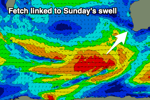
Moving into Sunday and our first of two pulses of W/SW swell is due to fill in, generated by a mid-latitude frontal progression that developed south-east of Madagascar tracking east and towards us over the coming days.
 The initial, strongest stages of this system has generated a slightly longer-period but less consistent swell for Monday, with a more consistent but similar sized pulse due Sunday from the developments closer towards us.
This swell should offer 6ft+ surf on Sunday (8ft bombs likely) across the South West, 2-3ft in Mandurah and 2ft+ across Perth, with Monday's less consistent pulse coming in at 6ft across the South West, similar in size to Sunday in Perth and Mandurah.
Winds will be great Sunday and offshore out of the E, giving into late afternoon sea breezes, if any, with moderate to fresh E/NE tending variable winds on Monday.
Tuesday looks less favourable as the swell eases with S/SE tending S/SW winds as a trough moves in from the west.
 Into Tuesday afternoon, the earlier stages of this trough will bring a new SW groundswell, generated by an off axis fetch of gale to severe-gale NW winds pushing through the southern Indian Ocean. We should see fun sets spreading out radially from this source, building to 5-6ft across the South West into the afternoon but with that onshore wind, easing Wednesday from 4-6ft with possible variable winds. Perth and Mandurah look to be small and to 1-2ft max.
Longer term it looks like we'll see a return of the onshore winds and fronts late week, but more on this Monday. Have a great weekend!

