Buckle up, we're in for another wild ride
Western Australia Surf Forecast by Craig Brokensha (issued Friday July 23rd)
Best Days: Possibly Perth and Mandurah early Wednesday
Features of the Forecast (tl;dr)
- Large to extra-large pulses of swell with winds being strong and switching from NW to W/SW with each passing front
Recap
Tiny clean waves across the Perth region yesterday, a bit better and reaching 2ft across the beaches in Mandurah, while Margs started slow but kicked to 4-6ft through the afternoon but with moderate onshore winds persisting all day.
Today all locations are poor and building with an increase in low-period swell and strong onshore winds.
This weekend and next week (Jul 24 - 30)
Here we go, we've got a large run of onshore, poor surf which will kick off from today, persist through the weekend, further next week and all of next weekend as well.
The reasoning for this is a strong node of the Long Wave Trough setting up over us, steering and strengthening polar fronts up and into us.
The first system under this setup is pushing through now, with a large kick in mid-period swell due to follow tomorrow, coming in around 10ft in the South West, 3ft+ across Mandurah and 3ft in Perth along with strong W/SW tending W winds.
 The swell should ease back through Sunday as winds strengthen from the W/NW ahead of the next front.
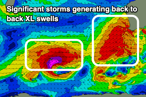
This will actually be drawn out fetches of gale to severe-gale, pre-frontal W/NW winds, producing a good W/SW groundswell for Monday, reaching a peak through the day to the 10ft range in the South West again, 3-4ft across Mandurah and 3ft in Perth.
Conditions will deteriorate further though with strengthening NW tending N/NW winds on Monday, ahead of a very significant cold front and XL swell developing through Tuesday, easing Wednesday.
This will be generated by a broad fetch of gale to severe-gale SW winds projecting up and across us through the weekend, into Tuesday.
The South West looks to still reach 15ft+ or so into Tuesday afternoon, easing from a similar size Wednesday with a peak to 4-5ft in Mandurah and 4ft across Perth. Winds will be strong from the W/SW as the front moves through, easing through the day, with Wednesday seeing winds pick up again from the NW as the next front approaches. There's a chance for lighter N winds at dawn in Perth and Mandurah but we'll review this on Monday.
This next frontal system will again be quite a significant one, with a polar low spawning off a couple of significant fronts which will project up and towards the state late week, bringing strong W/NW winds on Thursday ahead of the XL, long-period swell Friday.
Size wise this one looks bigger and to 15-20ft in the South West, 4-6ft across Mandurah and 4-5ft in Perth but with strong W/SW winds, easing Saturday with SW tending W/NW winds as secondary frontal systems continue to impact the state.
The frontal activity will weaken into next weekend and the following week, but persist keeping average winds and moderate sized swells impacting the state, but we'll have a closer look at this Monday. Have a great weekend!


Comments
Far out Craig - Possibly Perth and Mandurah early Wednesday and not much light at the end of the tunnel the following week.
Can you get a new crystal ball please.
Been a tough run for the weekend warriors of late. Future doesn't look too good either. Going to save up a sickie for when the inevitable mid-week offshore and swell lines up eventually.
Big down south today.
This kind of WA report gets me excited.
Really?.. it sure doesn’t excite me much. Cmon Huey.. give us some offshores!
I could imagine a certain shark infested spot cranking.