Large swells on the way, though not the cleanest
Western Australia Surf Forecast by Craig Brokensha (issued Monday February 15th)
Best Days: Tomorrow morning protected spots in the South West for the keen, Friday morning, Saturday morning in the South West, Sunday, Monday morning
Features of the Forecast (tl;dr)
- Easing mix of swells tomorrow with S'ly tending S/SW winds
- Large W/SW groundswell building Wed PM, peaking Thu with a close-range swell in the mix and strong to gale-force onshore W tending SW winds
- Easing W/SW groundswell Fri with morning SE winds, smaller Sat with a morning E/SE breeze
- XL SW groundswell arriving late Sat, peaking Sun AM with S/SE morning winds
Recap
Building surf through Saturday with clean, fun 4ft waves across the South West Saturday morning, bigger into the afternoon though wind affected, easing from a fun, clean 3-4ft yesterday. Mandurah and Perth were tiny Saturday morning, with a tiny little wave for the keen yesterday morning.
Today we've got our mix of mid-period and long-period SW groundswells with surf to 6ft already reported this morning across the South West, a touch bigger this afternoon. Mandurah was a small 1-2ft, though bigger now, tiny in Perth. Winds have shifted onshore across all locations as a weakening frontal progression edges in from the west-southwest.
This weekend and next week (Feb 16 - 21)
Today's mix of swells are due to peak later today/this evening, easing back in size from the 6ft range across the South West, 2ft in Mandurah and 1-2ft in Perth. Conditions will be bumpy though with a general moderate to fresh S'ly breeze, shifting more S/SW through the afternoon and evening.
 A low point in swell is expected Wednesday morning ahead of a large, new W/SW groundswell into the afternoon, peaking Thursday. The frontal progression linked to this swell was a touch weaker and not as well constructed as forecast last Friday, with a pre-frontal fetch of severe-gale W'ly winds being trailed closely behind by gale to severe-gale W/SW winds.
Size wise we should still see large surf, building Wednesday and kicking late to 8ft+ across the South West, peaking Thursday to 8-10ft+. Mandurah should see 2-3ft sets late Wednesday, 2ft in Perth, coming in more 3ft and 2-3ft respectively Thursday.
But.. as touched on last update the remnants of the swell producing storm is expected to form into a mid-latitude low off our south-west Wednesday, bringing strengthening W'ly winds into the afternoon, likely reaching gale-force Thursday morning before shifting SW-S/SW.
An additional SW windswell will be added to the mix as well, adding some additional size, with stormy 3-4ft waves in Mandurah, 3ft+ in Perth.
The low will clear quickly to the east Friday, swinging winds back to the SE through the morning with a mix of easing swells from 6ft to possibly 8ft in the South West, 2-3ft in Mandurah and 2ft+ across Perth.
 Saturday morning will be cleaner again with an E/SE offshore but a small, leftover swell.
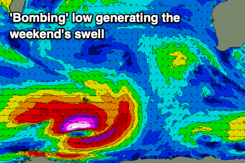
Of greater importance is a large, long-period SW groundswell due on Sunday, generated by a 'bombing' low forming around the Heard Island region Tuesday evening and Wednesday. A 'bombing' low is one which drops 24hPa or more in central pressure over a 24hr period, and we'll see this occur, with the central pressure dropping over double that!
As a result the low will generate a fetch of storm to hurricane-force W'ly winds, weakening slightly while projecting severe-gales east-northeast into the end of the week. This will generate an XL, long-period SW groundswell with it arriving late Saturday but peaking Sunday to 12-15ft+ across the South West, 3-4ft in Mandurah and 3ft across Perth. Winds look S/SE-SE, but we'll have to have a closer look at this on Wednesday.

