Good, long-range swell next week
Western Australia Surf Forecast by Craig Brokensha (issued December 23rd)
Best Days: Monday morning Margs for the desperate, Wednesday, Thursday morning
Features of the Forecast (tl;dr)
- Weak S/SW swell building tomorrow, easing Fri but windy
- Large, inconsistent W/SW groundswell for Wed/Thu with improving winds
Recap
Monday's good kick in swell eased back from 4-5ft yesterday with strong, tricky offshore winds, best from later morning as they abated, with clean, tiny waves to the north.
Today is clean again but the swell has backed right off, best across the South West swell magnets.
This week and weekend (Dec 24 - 27)
Looking at the outlook into the end of the week and we're due clean conditions at dawn tomorrow morning with an E/NE offshore but the swell will be at a low point and surfing options will be limited. A funky surface trough will then bring various wind changes through the day, though reverting to the S/SW through the afternoon along wth a building mid-period S/SW swell.
This swell was generated by a weak polar front that’s currently east of the Heard Island region. The fetch strength didn’t get close to gale-force, with the size only likely to reach 3-4ft on the South West swell magnets later tomorrow, easing from a similar size Christmas morning. Perth and Mandurah will remain tiny. There’s still also expected to be some infrequent long-period swell in the mix but with no size.
Winds will be less than ideal and fresh from the S/SE, tending S/SW and strengthening through the day Friday, stronger S/SE Saturday as the swell fades further.
Sunday looks no better as the swell bottoms out with strong morning SE winds.
Moving into next week, cleaner conditions should be seen Monday morning with a slight kick in small, mid-period S/SW swell but not above 2-3ft in Margs.
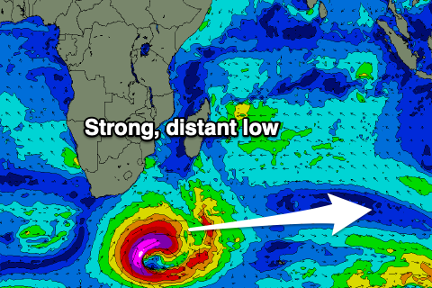
Of greater significance is the long-period, inconsistent W/SW groundswell due mid next week, with a significant low forming south of South Africa today.
 A fetch of severe-gale to storm-force winds will be projected towards is for a 1.5-2 days, before weakening slowly north-west of the Heard Island region.
The longevity of the low should generate a good, long-period W/SW groundswell with the fore-runners arriving Tuesday ahead of the swell proper on Wednesday.
Size wise we're looking at strong, though inconsistent sets to 6-8ft across the South West, 2ft to possibly 3ft in Mandurah and 2ft across Perth. There may be the rare sneaky bigger one across the South West, but we'll see how the low plays out.
Winds look a touch dicey and SE-S/SW on Wednesday, cleaner as the swell eases Thursday but more on this Friday. Have a Merry and safe Christmas!

