Good swell this week as winds slowly improve
Western Australia Surf Forecast by Craig Brokensha (issued Monday 16th November)
Best Days: Perth and Mandurah tomorrow and Wednesday mornings, Thursday morning, Friday morning in the South West, Saturday/Sunday morning
Recap
Friday's large W/SW swell eased back a touch through the weekend but fresh onshore winds created poor conditions across all locations Saturday, continuing Sunday with nowhere to really recommend for a surf.
Today conditions are cleaner across Perth and Mandurah with a reinforcing mid-period W/SW swell to 2-3ft with the South West bumpy though a bit better and increasing to 6ft through the day.
This week and weekend (Nov 17 - 22)
Today's reinforcing W/SW swell is due to peak this afternoon, easing slowly tomorrow as onshore winds persist and strengthen across the South West out of the W/NW.
Perth should see variable winds early and easing 2-3ft sets, while Mandurah looks a touch dicey and could be lingering onshore. Keep an eye on the local wind observations, Mandurah surfcam and dawn report for a clearer idea on the dawn conditions.
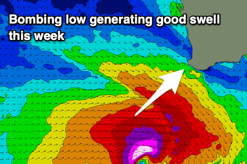
 We then look at the new long-period SW groundswell due into Wednesday, with the low that's currently deepening south-west of the state dropping more than 24hPa in central pressure within 24hrs, classifying it as a 'bombing low'.
We'll see the low aim the bulk of its fetch to the east, out of our swell window with pre-frontal gale to severe-gale W/NW winds followed closely by severe-gale W/SW winds.
These fetches will just be within our swell window initially, and a large though short-lived pulse of long-period SW groundswell is due, arriving Wednesday and kicking to the 8ft range across the South West, 2ft to possibly 3ft in Mandurah and 2ft on the sets across Perth during the morning.
The swell will ease into the afternoon, dropping back quickly Thursday from 5-6ft across Margs, 2ft in Mandurah and 1-1.5ft in Perth.
Winds on Wednesday morning when the swell peaks will remain onshore and fresh out of the W/NW, shifting SW-W/SW late morning. Perth and Mandurah should see variable winds early before swinging onshore through the morning.
Thursday is looking cleaner across all locations with light SE winds in Perth and Mandurah and more variable S'ly winds across the South West, with a more convincing offshore wind on Friday morning but with small leftover surf to 4ft or so on the magnets.
Into the weekend two pulses of mid-period W/SW swell are due both Saturday and Sunday from frontal systems firing up north of the Heard Island region tomorrow and Wednesday. Back to back fetches of strong W/SW winds are due, with the first system being the most favourable, bringing the most size on Saturday.
Margs should offer 5-6ft sets with small 1-2ft sets to the north and winds should be offshore each morning out of the E/SE-SE ahead of afternoon sea breezes.
Longer term we've got a possible low forming to our west-southwest later in the weekend/next week, bringing a new W/SW groundswell for next week, but more on this Wednesday.

