XXL swell and onshore winds inbound
Western Australia Surf Forecast by Craig Brokensha (issued Wednesday 15th July)
Best Days: Desperate surfers selected spots early tomorrow Mandurah and Perth, Saturday Perth and Mandurah, Sunday, Monday Margs and Mandurah
Recap
Poor, choppy and stormy conditions across all locations yesterday with a jack in localised windswell and groundswell.
This morning the surf remained poor in the South West but oversized, better to the north though lumpy and bumpy to 3-4ft in Mandurah, 3ft in Perth.
This week and weekend (Jul 16 - 19)
These notes will be brief as Ben's on annual leave.
Looking to our south-west and we've got the broadening and weakening remnants of the storm linked to our XXL swell to end off the week.
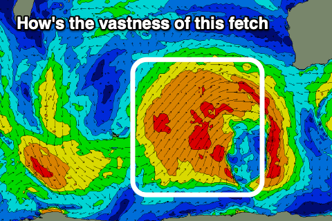
This storm generated a fetch of severe-gale to storm-force W/SW-SW winds on top an active sea state and is now weakening but still generating a vast fetch of strong to gale-force SW winds over half the size of Australia.
 Unfortunately this front and a secondary polar intensification on its tail will bring onshore winds for the peak of the swell.
Coming back to the size and tomorrow will see building mid-period energy from the remnants of the strong polar storm, but with strong N/NW tending W winds. Perth and less likely Mandurah may see N'ly winds at dawn though still moderate to fresh and with surf to 3ft+ or so.
Late in the day we may see sets from the new groundswell kicking to 15ft+ across the South West, with a peak overnight/Friday morning easing from 18-20ft. Mandurah should see 4-5ft sets and 3-4ft waves in Perth.
Unfortunately conditions will be poor across all locations with strong W/SW-SW winds, easing a touch out of the SW through the afternoon.
Saturday will remain onshore across the South West with strong SW winds, but Perth and Mandurah should see cleaner conditions with a light morning E/NE-NE breeze, tending variable ahead of weak afternoon sea breezes.
Size wise Mandurah should still be 3ft to occasionally 4ft, 2-3ft in Perth and easing.
Sunday still looks fun across all locations as a high moves in, swinging winds offshore from the SE tending E/SE though likely holding out of the SE into the afternoon.
The trailing polar front should help keep the size up as well to 6-8ft+ across the South West and 3ft in Mandurah on the sets, 2ft+ in Perth, with all coasts easing later.
There's plenty more on the cards for next week as a significant frontal progression bursts into the south-west Indian Ocean producing large and possibly oversized W/SW groundswells though with N'ly winds mid-week. More on this Friday.


Comments
Bloody good waves in the north of the state of late. But overrun by cashed up tourists trying to outdo each other with the size of their runabouts. One bloke was towing the Queen Mary around!
haha. Damn. That would explain why it's so quiet down South. Hallelujah!!