Easing swell through the weekend, becoming onshore through next week
Western Australia Surf Forecast by Craig Brokensha (issued Friday 5th June)
Best Days: Tomorrow morning, Tuesday, selected spots early Wednesday
Recap
Wednesday’s building W/SW groundswell held into yesterday morning with clean and great 4-6ft waves across the South West, 2-3ft in Mandurah and 2ft across Perth.
Today a new groundswell has filled in and we’ve got pumping 6ft surf in the South West, 2-3ft in Mandurah and 2ft across Perth again with conditions due to remain clean all day.
This weekend and next week (June 6 – 12)
Today’s new W/SW groundswell will start to ease over the weekend and we’ll see winds strengthen from the E/NE, shifting NE-N/NE through the afternoon and then easing late. Size wise the South West should ease back from 5-6ft in the South West, 2ft+ across Mandurah and 2ft on the sets in Perth, tiny into Sunday. The South West should still see 3-4ft sets Sunday morning but winds look dicey and light NW (N/NE early in Mandurah and Perth). There may be variable winds across the South West but with the swell, not worth worrying about.
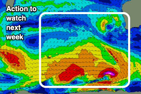
A low point in energy is expected Monday with morning E/NE winds, with our new inconsistent W/SW groundswells for Tuesday and then Wednesday still on track. A tight polar low ahead of a broader polar frontal progression south-east of South Africa have generated two swells that should be similar in size, though the first longer-period and the second less so.
The long-period swell might be seen later Monday but peak Tuesday to an inconsistent 5-6ft across the South West, 2ft in Mandurah and Perth on the sets. The secondary swell should keep wave heights around a similar size Wednesday.
 Conditions look best Tuesday morning with an E/NE offshore, shifting variable into the afternoon while Wednesday will see less favourable fresh NE tending strong N winds as a mid-latitude front moves in from the west.
The mid-latitude low will bring a moderate sized increased in onshore swell for Thursday, while a stronger polar front following it looks to generate a larger and onshore swell for late week/weekend, but we’ll have a closer look at this Monday. Have a great weekend!


Comments
Perth metro beaches looking pretty fun again!

Does look like fun. Nice wall on the right.
Not a bad run the last week.
Watched the Margs cam this morning, looked dead flat for ages. Then outta nowhere.. boom!


Perth metro beachies looking fun (tho small, and full) again.


Yeah not bad down at the harbour, still very full like everywhere else though , some screamers had by a few at (the rip), still dreaming of the Super Tuesday about 3 weeks ago.
Your local Timmy? I'll be home from a long stint Monday, hoping a shade of this 'Super Tuesday' presents it self
Yep I’m local , hope you get a few , I reckon that Tuesday was the best it’s been for years , anyways I’m off for a short stint at lambert on Monday
Nice weekend of waves here in the north. Like Margs., long lulls then beautful screamer sets.
Craig on leave, time to grieve.
I'll have the forecast up soon mate.
Appreciate the rhyme though.