Plan around next week
Western Australia Surf Forecast by Craig Brokensha (issued Wednesday 4th March)
Best Days: Every morning next week
Recap
Tiny to flat surf yesterday, with a very slight increase in W/SW swell today, but tiny across Perth and Mandurah, a very inconsistent 2ft to occasionally 3ft on the South West reefs as shown below..

This week and next (Mar 5 - 13)
This afternoon a new inconsistent SW groundswell should provide a little more action across the South West and into tomorrow, but we're only talking 3ft to occasionally 4ft sets on the swell magnets, and long waits for them.
The swell was generated south of South Africa, hence the inconsistency, while Perth and Mandurah should see tiny 1ft sets from a peak in mid-period W/SW swell.
Winds tomorrow morning aren't ideal and look moderate to fresh from the S/SE-SE across the South West ahead of strong S/SW sea breezes, strong S/SE on Friday as the swell starts to ease.
Come the weekend the surf will become small to tiny again and poor and onshore SW winds Saturday, S/SE tending SW on Sunday.
Looking into next week and out better groundswells are still on track.
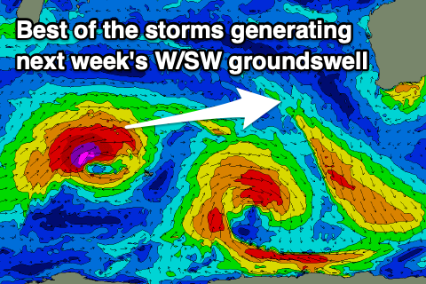
An initial low will form just east of the Heard Island region tomorrow evening, with a burst of gale to severe-gale W'ly winds projected through our swell window before the low weakens and then tracks east-southeast.
 A short-lived but good spike of long-period SW groundswell should be seen from the low, arriving late Sunday and peaking Monday morning.
The South West should see sets to 6ft on Monday morning, 2ft in Mandurah and 1-2ft across Perth and with fresh offshore E'ly winds ahead of afternoon sea breezes.
The swell is due to ease into Monday afternoon, smaller Tuesday with winds SE tending E/SE ahead of sea breezes.
The secondary pulse of W/SW groundswell is still on track for Wednesday afternoon and Thursday, produced by a more northerly positioned low, generating a fetch of severe-gale to storm-force W/SW winds Friday afternoon through Saturday morning, then breaking down north of Heard Island.
The swell should offer a touch more size than Monday's, kicking to 6ft+ across the South West later Wednesday, easing from the 6ft range Thursday morning. Mandurah should see 2ft to occasionally 3ft sets, 2ft in Perth.
As the swell eases though a new mid-period SW swell should fill in, produced by strengthening polar frontal progression early-mid next week.
It's likely to keep the surf up and around 6ft into Friday morning in the South West, 2ft Mandurah and 1-2ft Perth.
Winds should remain favourable through Wednesday and E/SE through the morning, S/SE-SE on Thursday, more SE Friday. We'll have a closer look at this on Friday though.

