Very lean period ahead
Western Australia Surf Forecast by Craig Brokensha (issued Wednesday 26th February)
Best Days: South West swell magnets tomorrow morning and South West south swell magnets Friday late morning and into the afternoon
Recap
Improving waves yesterday across the South West as winds swung more offshore and eased into the afternoon with 4ft of swell, similar today with bumpy conditions early but cleaner conditions now with a strong offshore and 3-4ft of swell.
To the north conditions are clean but tiny.
This week and weekend (Feb 27 – Mar 1)
Moving into the end of the week and we'll today's reinforcing S/SW easing back tomorrow, bottoming out overnight ahead of a new more acute S/SW groundswell building through the day.
Winds won't be as strong tomorrow during the morning and offshore out of the E-E/NE, fresh and possibly strengthening a little into the mid-late afternoon.
 Easing sets from 3-4ft are due across the South West swell magnets, tiny to the north, while Friday's swell should kick back to 4ft+ across the South West south swell magnets, bigger east of Cape Leeuwin.
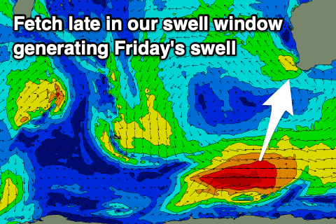
The source of this swell is a tight polar low that formed south-east of Heard Island and produced an unfavourably aligned fetch of severe-gale W/NW-W winds while moving east through our southern swell window.
Winds are a little tricky but mostly favourable, E/NE on the northern half of the cape early, E/SE-SE on the southern half, swinging N/NE late morning and strengthening into the afternoon.
This will favour those more exposed breaks to the southerly groundswell as it peaks into the afternoon.
Come Saturday onshore N/NW winds are due in the morning, favouring spots east of Cape Leeuwin with a drop in S/SW groundswell, average to the north and winds will shift W'ly into the afternoon.
As touched on in the last update, longer term we've got no new decent swell due into Sunday or early next week with small, fading waves with a fresh to strong SE breeze on the former, more offshore Monday and Tuesday but tiny.
Some long-range and very inconsistent background groundswell energy is due mid-late week, but it's being generated south of South Africa by a fairly mediocre polar low.
Size wise, we'll be lucky to see much over 3ft to maybe 4ft in the South West late Wednesday and more so Thursday, tiny in Perth and Mandurah. Morning winds look offshore but the wait between sets 10 minutes or so.
Beyond this the outlook remains very quiet.

