Easing surf, with swells with a bit more south from the weekend
Western Australia Surf Forecast by Craig Brokensha (issued Wednesday 22nd January)
Best Days: Protected spots tomorrow, South West Friday, Saturday and Sunday mornings, Tuesday morning in the South West
Recap
Poor conditions across all locations yesterday morning with a small swell and onshore winds, building through the day while today our large SW groundswell has filled in. Protected spots were the only option in the South West, much cleaner and great in Mandurah to 3ft, 2ft in Perth.
This week and weekend (Jan 23 - 26)
Today's large SW groundswell is set to ease steadily over the coming days as winds slowly improve.
Tomorrow will still be only decent in protected spots in the South West with an early S'ly breeze shifting S/SW mid-morning and strengthening. Further north conditions will be better with S/SE breezes and the swell should drop from 5-6ft in the South West, 2ft in Mandurah and 1-2ft across Perth.
 Friday looks nice and clean with a morning SE-E/SE offshore across the South West, S/SE-SE to the north. Locations north of Margs will be tiny though, with easing surf from the 4ft range across the magnets to the south.
Our small background spike of SW swell for Saturday is still on track, with a bit of S/SW groundswell in the mix as well.
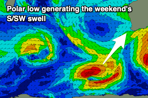
This is being generated by a south-east tracking and deepening polar low south-west of us, with a fetch of W/SW gales due to be generated in our south-western and southern swell windows.
The swell should provide fun waves cross the south swell magnets in the South West with sets to 4-5ft on Saturday when it peaks, easing into Sunday from a small 3ft+ or so. Perth and Mandurah aren't expected to see any size from this swell with it being too south in nature.
Morning SE winds will create decent conditions ahead of sea breezes both Saturday and Sunday.
Our tricky and more S'ly swell for early next week looks on track, with a stalling fetch of strong to gale-force W/SW winds just within our swell window due to generate the swell on the weekend.
The swell is due to build later Monday but peak Tuesday to 4-5ft across then South West swell magnets with a morning offshore breeze, easing Wednesday as winds shift back onshore.
Longer term a series of mid-latitude frontal systems are due to develop south-west of us early-mid next week, generating fun swells later week, possibly larger into next weekend, but more on this Friday.

