Large swells to come but with tricky winds
Western Australia Surf Forecast by Craig Brokensha (issued Wednesday 25th December)
Best Days: Selected spots early tomorrow, Perth and Mandurah Friday and Saturday mornings, keen surfers protected spots Mandurah Sunday morning, protected spots Monday morning, Tuesday morning
Recap
A small window of OK waves across the South West yesterday morning with Monday afternoon's small pulse of swell hanging in around 3ft+ with SE breezes, swinging onshore shortly afternoon. Perth and Mandurah saw a slight lift in swell but only for beginners.
Today a large new W/SW groundswell is on the build, a little bumpy but to 4-6ft this morning in the South West with 2ft sets to the north. We should see the swell reaching 6-8ft+ across the South West this afternoon, 2-3ft in Mandurah and 2ft to occasionally 3ft in Perth but with sea breezes.
This week and weekend (Dec 26 - 29)
This afternoon's large W/SW groundswell is due to peak later today and ease off slowly through tomorrow, though winds are now looking a little hit and miss as a surface trough just to our west moves in from the east.
Dawn may see light S/SE winds across the South West, N/NE in Mandurah and Perth but shifting onshore from the S/SW and NW respectively mid-morning. There'll still be plenty of size with easing 6ft+ sets in the South West, 2ft to occasionally 3ft in Mandurah and 2ft in Perth. Get in early for the best of it
Friday will be a lay day with onshore SW winds across the South West, though Perth and Mandurah will have small 1-2ft waves with a morning S/SE breeze.
 This onshore wind will be linked to a weakening frontal system pushing towards us, producing a weak SW swell for Saturday morning but with persistent onshore W/SW winds across the South West. Perth and Mandurah look the best again with small 1-2ft sets and a morning S/SE breeze.
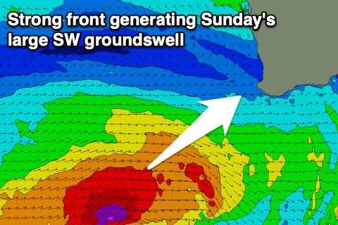
Of greater importance is a much stronger mid-latitude frontal system developing on the tail of the weak front, with a fetch of gale to severe-gale W/SW winds forecast to be generated through our south-western swell window from later this afternoon through Saturday morning.
A large, long-period SW groundswell is expected off this progression, showing later Saturday but peaking Sunday 8-10ft in the South West and 2-3ft in Mandurah and Perth. Unfortunately a secondary mid-latitude front will move in Sunday bringing strengthening onshore NW tending W/NW winds around Margs, S/SW tending W to the north.
Some new swell from the front will soften the easing trend into Monday as winds shift more S/SW-S (S/SE further north) with surf to 6-8ft persisting in the South West, 2ft to occasionally 3ft to the north.
Tuesday looks the pick as winds swing to the E/SE with easing mid-period SW energy from the 6ft range in the South West, 2ft+ in Mandurah and 2ft in Perth.
Longer term another low forming to our south-west looks to generate a fun SW swell for late next week, but more on this Friday.

