Clean and fun waves over the period
Western Australia Surf Forecast by Craig Brokensha (issued Friday 26th July)
Best Days: Saturday, Sunday protected spots, Monday, Tuesday, Wednesday and Thursday selected spots
Recap
A large mix of new swells punching a bit above expectations in the South West with sets to 8-10ft and good waves in protected spots with a S/SE breeze, lumpy to the north with variable morning winds and 3ft sets in Mandurah, 2-3ft in Perth.
Today a moderate to fresh offshore wind is creating excellent waves across the South West with easing surf from the 8ft range, 3ft in Mandurah and 2-3ft in Perth.
Today’s Forecaster Notes are brought to you by Rip Curl
This weekend and next week (Jul 27 – Aug 2)
The coming weekend and general period of surf is looking good to great with favourable winds and good pulses of swell.
The swell will continue to ease tomorrow, slowed by a reinforcing SW pulse, generated by a front spawning off a stronger low that's due to generate a new large long-period SW groundswell for Sunday.
Size wise, Margs should still be a good 6ft tomorrow morning, 2ft+ in Mandurah and 1-2ft in Perth, while the new inconsistent SW groundswell for Sunday should build to 6-8ft, 2ft+ and 1-2ft respectively through the day, possibly a little undersized early.
Winds tomorrow morning will be good but not as good as this morning with a fresh SE'ly, more S/SE into the afternoon and then less favourable S/SE wind on Sunday.
Better E/NE offshore winds are expected to kick back in on Monday, light S'ly into the afternoon as Sunday's SW groundswell eases. Tuesday will be smaller again but with great morning E/NE offshore winds, N/NE into the afternoon in the South West but variable to the north.
Wednesday morning will start a little smaller again, but later in the day a new long-period W/SW groundswell is due to kick hard, peaking on Thursday.
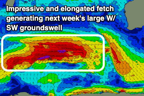
 As talked about in Wednesday's update, a strong and slow moving frontal progression forming south of South Africa today will push east through the southern Indian Ocean over the weekend and into early next week.
Various fetches of severe-gale W/SW winds will be projected through our western swell window, with a couple of burst of storm-force winds on the cards.
The progression will have two phases, generating two seperate large and long-period W/SW groundswells, but they'll arrive around the same time Wednesday afternoon, building to 6-8ft by dark across the South West and then peaking Thursday to the 10-12ft range, 3ft+ in Mandurah and 2-3ft in Perth.
With the two swells there may be some funky close-spaced and mixed sets. Winds won't be great and will only favour select locations with a gusty NE tending N/NE breeze on Wednesday and then similar moderate to possibly fresh N/NE winds on Thursday. Come Friday as the swell eases a trough and possible low moving through look to bring a SW change, early from the N/NE.
Longer term there's plenty of swell to follow into next weekend and beyond but the storms generating these look to interfere with the local winds. More on this Monday. Have a great weekend!


Comments
Pump town..
Margaret river cam has not been working for me for a while now. Just a grey screen, using safari.
Can you try Chrome please? How long is “a while”... days, weeks, months? Are any other cameras working for you?
Wow perfection.