Winds finally swing offshore across the South West
Western Australia Surf Forecast by Craig Brokensha (issued Wednesday 24th July)
Best Days: Thursday all spots, Friday all spots, Saturday morning Margs and Mandurah, Sunday and Monday all locations, Tuesday in the South West
Recap
Large and easing onshore waves across the South West yesterday, cleaner to the north in the morning with easing 3-4ft sets across Mandurah and 3ft in Perth.
Today the swell has eased further and winds have remained onshore in the South West, cleaner to the north and to 2-3ft.
Today’s Forecaster Notes are brought to you by Rip Curl
This week and weekend (Jul 25 – 28)
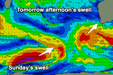
A strong frontal system that's currently to our south-west will generate a mix of mid-period and longer period groundswell for tomorrow afternoon, kicking the South West back to the 8ft range, if not for the odd bigger sneaker, 3ft on the sets in Mandurah and 2ft+ in Perth.
Winds will finally improve across Margs, swinging moderate to fresh S/SE, similar to the north, if not for a little more SE tendency through the morning. Winds should hold all day, possibly tending more SE across the South West later as the swell peaks into the afternoon.
 A drop in size is due on Friday from 6-8ft in the South West, 2-3ft in Mandurah and 2ft in Perth with better E/NE morning offshore winds, shifting more N'th into the afternoon and possibly variable later.
Saturday looks a little smaller, but a new reinforcing SW groundswell will slow the easing trend, generated by the remnants of a polar low linked to a better long-period swell on Sunday.
This low is generating a tight fetch of severe-gale to storm-force in our far swell window, west of Heard Island, producing a new inconsistent SW groundswell for Sunday, but it will quickly race ahead of itself in a weakened form over the coming days, producing a pre-frontal W/NW fetch south-west of us tomorrow.
The new mid-period SW swell is due to ease from 5-6ft in the South West Saturday, though only a small 2ft in Mandurah and 1-1.5ft in Perth. Winds look favourable and out of the SE Saturday morning, S/SE into the afternoon, while Sunday looks to play out similar.
The new long-period is expected to provide a kick in size to an inconsistent 6-8ft in the South West on Sunday, 2ft+ in Mandurah and 1-2ft in Perth, easing Monday from a smaller size with great E tending variable winds.
Longer term, the larger W/SW groundswell mentioned for later next week in Monday's notes is still on the cards, but looks to come from a more SW angle.
A slow moving and strong and elongated frontal progression forming south of South Africa Friday will push east while generating various fetches of severe-gale W/SW winds towards us, with one burst of storm-force W/SW winds on the cards from a follow up system.
This will generate a couple if not three pulses of long-range turning medium/close range groundswell, the first arriving late Wednesday and peaking Thursday with a follow up Friday.
Size wise we're looking at surf in the 10ft range across the South West, 3ft in Mandurah and 2-3ft in Perth but with the remnants of the frontal activity may edge into the state, bringing onshore winds. The models diverge on this though so check back here Friday for an update.


Comments
Decent..