Large easing onshore surf, smaller swells next week
Western Australia Surf Forecast by Craig Brokensha (issued Wednesday 22nd May)
Best Days: Mandurah and Perth tomorrow morning, Mandurah Friday morning, protected spots in the South West Saturday morning, Sunday desperate surfers magnets in the South West, Monday morning in the South West
Recap
Poor conditions across the South West with no real size and onshore winds, while to the north the waves were better with clean 1-2ft surf in Mandurah, 2ft in Perth.
Today our better SW groundswell has filled in and we should see it peaking this afternoon. Margs was 6-8ft this morning and poor early but improved as winds tended more variable, while Perth and Mandurah were much better with clean 2-3ft surf.
Today’s Forecaster Notes are brought to you by Rip Curl
This week and weekend (May 23 – 26)
Today's large SW groundswell will ease off slowly through tomorrow across all locations, likely from 2-3ft around Mandurah and Perth with 6-8ft sets in the South West.
Winds will unfortunately linger from the W/SW across Margs and be moderate in strength, with Mandurah and Perth likely to see early E/NE-NE winds and cleaner conditions.
The downwards trend looks to be fairly steady with our reinforcing swells not looking to be that significant at all.
 Winds will play out similarly into Friday, onshore in the South West and lighter and more variable to the north as the size continues to ease. The South West should see 4-6ft surf, with easing 2ft sets in Mandurah, 1-2ft around Perth.
Saturday looks smaller again with easing 4-5ft sets in the South West, 1-2ft in Mandurah and 1-1.5ft Perth but winds will finally start to improve. A S/SE'ly should create OK conditions in protected spots in the South West, more favourable and from the E/SE further north.
Sunday will finally see a better offshore E'ly wind in the South West, but the surf looks smaller and to 3ft+ in the South West, tiny to the north. A new inconsistent long-period SW groundswell is due to arrive into the afternoon but with sea breezes, peaking Monday.
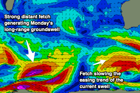
This is being generated by a short-lived fetch of polar severe-gale to storm-force W/NW winds to the south-west of Heard Island and only looks to provide inconsistent but good quality 4-5ft+ sets across the South West, small to tiny further north. Winds on Monday will be favourable and offshore from the E/SE in the morning, so hit the South West swell magnets.
Longer term and the significant storm that was forecast to develop south-east of South Africa looks to now be broader, weaker and misaligned for our region, developing around the Heard Island region and being quite meridional (south to north).
This isn't ideal and we're not expected to see any significant swell at all now into later next week, just a moderate sized and inconsistent W/SW groundswell.
Winds may become an issue now as the remnants of the storm start to move in from the west bringing northerly breezes, but we'll have a closer look at this on Friday.


Comments
Hey Craig that system that is meridional, will that send a good swell to the Ments by any chance???
hey mate, Indo forecast notes are being serviced by Swellnet Traveller: https://www.swellnet.com/traveller