Good surf around Perth and Mandurah, better in the South West from the weekend
Western Australia Surf Forecast by Craig Brokensha (issued Monday 20th May)
Best Days: Perth and Mandurah Tuesday, Wednesday and Thursday mornings, Margs and Mandurah Sunday morning
Recap
Good fun and clean easing surf from 3-4ft in the South West Saturday morning, 2ft in Mandurah and tiny in Perth. Sunday was average as onshore winds started to move in, tiny to the north.
Today the surf is poor across all locations with small to tiny and building swells.
Today’s Forecaster Notes are brought to you by Rip Curl
This week and weekend (May 21 – 26)
Tomorrow will remain average and onshore across the South West, with no new swell due until later in the day and more so Wednesday. Mandurah and Perth should be fun though with a light E/NE offshore and small 1-2ft of W'ly swell.
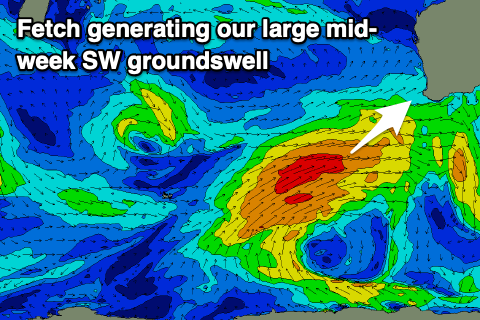
 The strong and slow moving polar front generating Wednesday's SW groundswell is to our south-west, projecting a slightly weaker than forecast fetch of W/SW gales through our swell window.
The front will continue moving slowly east tomorrow and out of our swell window, with the swell filling in Wednesday and peaking through the day (afternoon to the north).
Margs now looks to come in around 8-10ft, 2-3ft in Mandurah and 2ft+ in Perth but with unfavourable N tending NW winds in the South West, E/NE further north ahead of sea breezes.
Thursday will unfortunately see onshore W/SW winds as the swell eases in the South West, cleaner around Mandurah and Perth again with light E/NE offshores. Friday looks to play out similar as weak fronts clip the south-west of the state, clean to the north of Margs but bumpy and onshore otherwise as the swell continues to drop.
We'll finally see some sort of offshore wind on Saturday across the South West, though S/SE and with smaller amounts of surf to 3-5ft or so, tiny to the north.
A late strengthening front to our south-west later this week will produce a fetch of gale to severe-gale W/SW winds late in our swell window, generating a fun new S/SW swell for Sunday.
The swell will favour the South West over locations to the north and hopefully come in at 5-6ft, 1-2ft in Mandurah and tiny around Perth. Conditions look even better with a straight E'ly offshore wind across all locations.
Longer term a good new long-period W/SW groundswell is on the cards for next week as a strong and intense low forms south-east of South Africa. It's currently forecast to generate a fetch of severe-gale to storm-force W/SW winds in our far western swell window, with an inconsistent long-period W/SW groundswell arriving later week with what looks to be favourable winds. Size wise we're looking at surf in the 8-10ft range, but more on this Wednesday.

