Decent swell for the weekend but with tricky winds
Western Australia Surf Forecast by Craig Brokensha (issued Friday 10th May)
Best Days: Early tomorrow, Mandurah Sunday morning, Tuesday morning
Recap
Great conditions across the South West yesterday morning with a drop in swell to 4-5ft, though a new inconsistent long-period W/SW groundswell built into the afternoon and provided larger 6-8ft sets with variable winds. Perth and Mandurah were around 2ft, pulsing a little into the late afternoon.
Today's larger increase in swell has come in a little under expectations with Margs hanging in around a pumping 8ft this morning, 2-3ft in Mandurah and 2ft+ in Perth.
Today’s Forecaster Notes are brought to you by Rip Curl
This weekend and next week (May 11 – 17)
The surf should remain large across the South West tomorrow as a reinforcing long-period S/SW groundswell fills in, produced by a significant storm that's currently east of Heard Island.
Satellite observations have confirmed a late forming fetch of severe-gale to storm-force W'ly winds on the edge of our southern swell window, with the groundswell arriving through the afternoon tomorrow.
The morning looks to be back to 6ft or so, with the new swell pulsing to 6-8ft, with 2ft waves in Mandurah, and possibly the rare 3ft set, 1-2ft in Perth.
Winds will be best early and out of the E/NE, shifting quickly to the N/NE through the late morning and persisting into the afternoon.
 Sunday now looks generally average with an onshore change expected to now move in on dawn in the South West, with morning NE breezes in Perth and Mandurah but small easing surf.
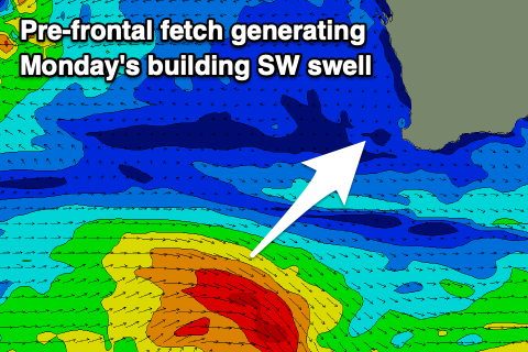
Our new SW swell for Monday is on track, though it looks to be mostly mid-period energy, with the low generating it forming a little late in our swell window. A weak fetch of pre-frontal W/NW winds will be aimed through our swell window, with the swell likely to only reach 4-5ft+ in the South West, 1-2ft in Mandurah and tiny in Perth.
Winds are looking suss as well now in the South West with a S'ly breeze lingering from Sunday's change, E/SE further north in Perth and Mandurah.
Tuesday will be much better with a morning E/NE offshore and easing surf from 3-5ft in the South West, tiny to the north.
A better long-period SW groundswell is due Thursday, produced by a strong but weirdly structured polar low forming east of Heard Island early next week. A thin though elongated fetch of severe-gale to storm-force W/sW winds are forecast, with the swell due to arrive late Wednesday ahead of a peak Thursday.
At this stage Margs should reach 6ft+ Thursday morning, with 2ft waves in Mandurah and 1-2ft sets in Perth.
Winds are up in the air at the moment with the models divergent on a trough moving in from the west, so check back here on Monday for a clearer idea on what we can expect. Have a great weekend!

