Good swell this week, best as it eases
Western Australia Surf Forecast by Craig Brokensha (issued Monday 29th April)
Best Days: Protected spots tomorrow afternoon in the South West, through the day further north, all coasts Wednesday morning, Margs Thursday morning
Recap
Saturday was the pick of the weekend with clean 4ft waves around Margs, 2ft in Mandurah and 1-2ft in Perth, good again early Sunday morning but small to tiny.
Today onshore winds are in with a small new W/SW swell.
Today’s Forecaster Notes are brought to you by Rip Curl
This week and weekend (Apr 30 – May 5)
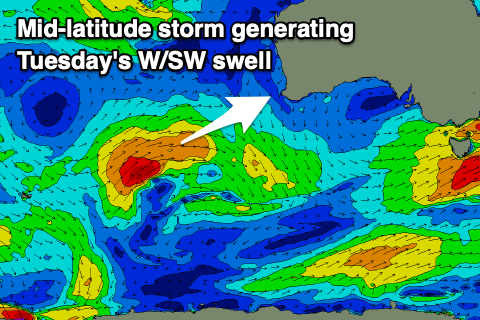
Moving into tomorrow and we should see our large new W/SW groundswell building, but the size and intensity has unfortunately been downgraded a touch since Friday.
The mid-latitude storm linked to it was a little weaker than expected over the weekend, with a broad and good fetch of strong to gale-force W/SW winds aimed towards us, weakening on approach today.
 With this I've downgraded the expected peak in size with a slightly later arrival time. We should see the swell build tomorrow, peaking through the afternoon to 8ft on the sets across the South West, 2-3ft in Mandurah and 2ft in Perth along with an average S'ly breeze in the South West, S/SE further north.
Wednesday still looks the pick with offshore E/SE winds and easing sets from 5-6ft+, 2ft+ and 1-2ft respectively from Margs, Mandurah and Perth.
Thursday will be smaller and best in the South West with a morning E/NE offshore and easing 3ft+ sets, tiny to the north.
A very inconsistent long-range background swell is due Friday but with morning NE-N/NE winds options will be limited as the swell isn't expected to provide much size above 3-4ft in the South West.
Saturday will see the swell ease with strengthening N/NE tending N/NW winds as small mid-latitude low moves in from the west-northwest.
The low will be short-lived and only generate a short burst of strong to gale-force W/SW winds through our western swell window Saturday evening, with sets to 4-6ft due around Margs Sunday morning, 2-3ft in Mandurah and 2ft+ in Perth but with onshore NW winds.
A secondary low is forecast to move in early next week, likely generating a larger increase in W/SW swell, but more on this Wednesday.


Comments
Nice looking lines at Yalls this arvo.
