Slow week with more favourable winds
Western Australia Surf Forecast by Craig Brokensha (issued Monday 17th December)
Best Days: South West swell magnets Wednesday later morning with the building swell, Thursday morning, Friday morning, Monday week (Mandurah included)
Recap
A large powerful swell filled in over the weekend but conditions were only good in protected spots across the South West and Mandurah, poor in Perth.
The swell has eased further into today with unfavourable S'ly winds across the South West and easing 3-4ft sets, small and bumpy in Mandurah and Perth.
Today’s Forecaster Notes are brought to you by Rip Curl
This week and weekend (Dec 18 – 23)
As touched on last update, the coming week isn't great at all swell wise, but conditions will improve with better offshore winds due most of the week.
Size wise, tomorrow looks small and easing with a low point Wednesday morning.
We're looking at easing 3ft sets across the South West swell magnets with tiny waves in Perth and Mandurah and with a S/SE-SE breeze which won't be ideal.
On Wednesday a new mid-period SW swell is due to fill in, but the size is mostly due into the afternoon and Thursday morning.
The source of this swell was a weak polar low generating a prolonged fetch of strong winds through our swell window around the Heard Island region.
 The surf should build to 3-4ft, with the likelihood of 5ft sets across magnets later Wednesday, easing from a similar size Thursday, smaller Friday and down from 3ft or so. Perth and Mandurah will remain tiny.
A better E/SE offshore wind should be seen Wednesday morning as the swell starts to build, with afternoon sea breezes.
Thursday should see SE tending E/SE breezes before the afternoon sea breeze kicks in (possibly holding from the S/SE all day in the South West). Good E/SE winds will create clean conditions again on Friday but with the small easing swell.
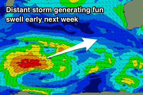
Moving into the weekend and Saturday looks like a lay day with a further drop in size and less favourable S/SE morning breeze, while a new long-range and mid-period SW swell is due to arrive through Sunday, building into the afternoon and peaking Monday morning.
The storm generating this swell looks to be a touch stronger than the one linked to our mid-week swell, with a fetch of slow moving strong to gale-force W'ly winds currently west of Heard Island being the source.
Inconsistent but fun 4-5ft sets are due to develop late Sunday and peaking Monday to 4-6ft across the South West, 1-2ft in Mandurah but tiny in Perth. Winds Monday morning at this stage look SE, but we'll review this Wednesday.


Comments
Hey Craig, long way off but any thoughts on whats going on from 26/27th with GFS combining ex TC's and moving them into southern ocean and predicting another TC up north?
Hey mate, yeah that's a long way out at this stage, but looks to be fairly consistent in model land. It looks like they will dip south and not favourably through our swell window. One to watch though.