Our active period continues
Western Australia Surf Forecast by Craig Brokensha (issued Friday 7th December)
Best Days: Margs and Mandurah tomorrow morning, Sunday morning all locations, Margs Monday morning, Wednesday morning Margs and Mandurah
Recap
Pumping waves across the South West yesterday morning with a clean easing 6-8ft of swell, 2-3ft in Mandurah and small to tiny in Perth with a period of variable winds early-mid morning.
The swell has eased back into this morning with a period of clean conditions early again across Margs, now onshore with leftover 2ft waves in Mandurah, and a bumpy 1-1.5ft in Perth.
Today’s Forecaster Notes are brought to you by Rip Curl
This week and weekend (Dec 8 – 14)
A low point in swell is due later this afternoon/evening and from here we'll see new SW swell energy filling in, mid-period in nature tomorrow morning ahead of long-period energy into the afternoon.
There's been no change to the expected size of this swell, with Margs due to build to 8ft+ late afternoon tomorrow, 2-3ft in Mandurah and 2ft in Perth, easing slowly Sunday from 6ft+, 2ft and 1-2ft respectively.
Conditions are looking good each morning over the weekend with Margs cleanest tomorrow with an E/SE offshore, while to the north we may see slightly less favourable S/SE-SE winds ahead of sea breezes.
Sunday morning should reveal better SE winds across all locations ahead of sea breezes.
 The easing trend will be slowed into Monday as a mid-period SW swell fills in, generated by a relatively weak but broad mid-latitude front moving in from the south-west today, passing under us tomorrow.
Margs should still offer 4-5ft sets, 1-2ft in Mandurah but tiny around Perth. Winds look to be more S/SE than SE across the South West, but workable, while better offshore E/SE breezes are likely around Perth and Mandurah.
We've got another good pulse of SW groundswell due to build Tuesday and ease Wednesday, generated by a relatively weak but persistent fetch of W'ly gales being projected through our south-western swell window from tomorrow afternoon through Sunday, between Heard Island and us.
A moderate to large sized SW groundswell is expected to build Tuesday afternoon, reaching 6ft+ late in the day across the South West and easing from a similar size on Wednesday morning. Mandurah only looks to kick to 2ft, with 1-1.5ft waves in Perth.
Winds look dicey Tuesday and onshore as a mid-latitude front clips the state, while a return to S/SE winds is expected on Wednesday.
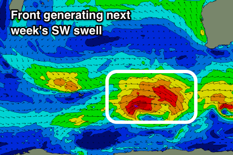
Longer term we may see a larger long-period SW groundswell developing for next weekend, but we'll have a closer look at this Monday. Have a great weekend!


Comments
I miss the west the sunsets the solid surf even the flies.
Margs looking strong this morning.

