Onshore, onshore, onshore, with good windows to the north
Western Australia Surf Forecast by Craig Brokensha (issued Friday 7th September)
Best Days: Perth and Mandurah Sunday morning, Tuesday morning and Wednsday morning
Recap
Pumping waves across Perth and Mandurah yesterday with an offshore wind and good sized easing W/SW groundswell, onshore and poor across the South West.
Today, the swell was smaller and onshore across all locations.
Today’s Forecaster Notes are brought to you by Rip Curl
This weekend and next week (Sep 11 – 17)
Today's onshore change is linked to a weakening but broad polar front clipping the south-west of the state, and with this a new pulse of mid-period SW swell is due to fill in tomorrow.
Conditions will be poor though with another much stronger front approaching from the west-southwest, resulting in moderate to fresh W/NW winds across all locations.
The South West should kick to 6ft+ with 2-3ft waves in Mandurah and 2ft+ surf in Perth, but of greater significance is Sunday's swell.
A relatively weak front that's currently north of the Heard Island region is expected to strengthen significantly under the influence of a node of the Long Wave Trough that's developing to our west.
We'll see a fetch of severe-gale to storm-force W'ly winds generated in our south-western swell window before the front pushes onwards under the country.
A large long-period SW groundswell will result, filling in Sunday and peaking through the middle of the day/afternoon.
The South West should reach the 10ft range, if not for the odd bigger cleanup, building to 3ft+ in Mandurah and 2-3ft in Perth with a window of NE winds before the swell fills in proper.
 Margs will remain poor and onshore with a fresh and gusty NW breeze.
Onshore winds look to kick in again across all breaks on Monday as the swell eases, owing to a multi-staged and strengthening polar frontal progression approaching from the west.
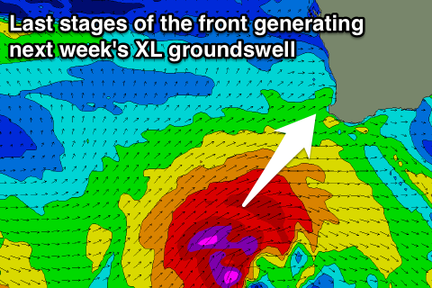
This progression will develop in the Heard Island region again on Saturday, with a fetch of SW gales being projected north towards us, before a secondary fetch of severe-gale SW winds push in on top of the active sea state and pass right under us on Monday evening and Tuesday.
An XL SW groundswell is expected off this progression, building Tuesday afternoon but with fresh SW winds in the wake of the front. Perth and Mandurah are likely to see morning S/SE breezes, but we'll confirm this on Monday.
Size wise, Margs should see 12ft+ surf into the afternoon, with 3-5ft waves in Mandurah, 3ft in Perth, easing Wednesday though still onshore as yet another front pushes in from the south-west.
There's a good chance for E'ly winds in Perth and Mandurah Wednesday morning, but check back Monday for an update on this.
There's plenty more swell on the cards for late week and into the weekend, but we'll have a closer look at this on Monday. Have a great weekend!

