The Long Wave Trough comes back to town
Western Australia Surf Forecast by Craig Brokensha (issued Monday 3rd September)
Best Days: Protected spots in the South West Wednesday, Perth and Mandurah Thursday morning
Recap
Good clean conditions most of the weekend with smaller levels of swell but good fun waves on the magnets Saturday, dropping back a touch more into Sunday.
This morning we're back to small onshore waves across the South West and cleaner but tiny waves to the north.
Today’s Forecaster Notes are brought to you by Rip Curl
This week and weekend (Sep 4 - 9)
Winds are currently increasing out of the west across all locations as a strong and slow moving polar front pushes up from our west-southwest.
This frontal progression formed later last week and an initial fetch of strong to gale-force W/SW winds set up an active sea state for a stronger and slow moving fetch of gale to near severe-gale W/SW winds to move over.
We'll see the front weaken while pushing across us tomorrow afternoon and evening, with a poor building windswell and strengthening W tending W/NW winds.
 An oversized W/SW groundswell will fill in on Wednesday along with strong but easing SW winds.
We should see Margs building to a messy 12ft+ through the day, with bigger bombs at deep water reefs, while Mandurah should build to 4-5ft, with 3-4ft surf in Perth.
Unfortunately the high that the models had progged on Friday to move in following the front has been reverted back to another frontal system and this will unfortunately bring onshore W/SW winds across Margs as the swell eases on Thursday.
Perth and Mandurah should see morning E/NE offshores and good clean easing surf from 3ft and 3-4ft respectively. Friday then looks poor across all location as a strong polar front projects closer towards us bringing fresh W'ly breezes.
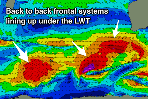
This front will generate a good new large SW groundswell for Saturday, the first of a flurry of large onshore swells due through the weekend and next week as a strong broad node of the Long Wave Trough strengthens and sits over us.
This first front will project a fetch of W/SW tending SW gales through our south-western swell window over the coming days, with the swell arriving through Saturday and building to the 10ft range across magnets in the South West, 3ft in Mandurah and 2ft to maybe 3ft in Perth.
A secondary more northerly positioned front will then races in on Friday and Saturday, generating a similar sized reinforcing SW groundswell for Sunday afternoon and Monday.
Behind this more large W/SW groundswell is due, but with the LWT sitting over us, we'll see persistent onshore winds from each front pushing across us, with possible small windows of better conditions across Perth and Mandurah - like Sunday.
We'll have a closer look at all of this on Wednesday though.


Comments
we still gotta a negative SAM?
Nah it's gone positive. This doesn't stop such a strong and pronounced node of the LWT developing as is forecast through the coming fortnight.