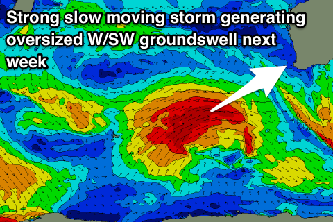
A weekend for swell magnets, oversized groundswell next week
Western Australia Surf Forecast by Craig Brokensha (issued Friday 31st August)
Best Days: All locations tomorrow morning, Margs swell magnets Sunday morning, protected spots Wednesday afternoon, all locations Thursday and Friday mornings
Recap
Workable waves for keen surfers across all protected locations yesterday morning with an easing mix of swells under a gusty S'ly wind. Conditions deteriorated into the afternoon with a drop in swell and swing in winds more onshore.
Today Mandurah and Perth were clean and fun with an easing SW swell from 2-3ft on the former and 2ft later, with onshore small waves in the South West.
A new SW groundswell is due to kick later today across Margs, but with no change to the winds.
Today’s Forecaster Notes are brought to you by Rip Curl
This week and weekend (Sep 1 - 7)
Later today's increase in distant SW groundswell is due to peak overnight, and ease off slowly through the weekend as winds improve across the South West.
A strong and slow moving high will swing winds around to the E/SE tomorrow morning across Margs (E/NE further north) with the SW groundswell easing from 4-6ft, 2ft in Mandurah and 1ft to possibly 2ft in Perth.
Sunday will be smaller again, tiny in Perth and Mandurah, while a small new S/SW groundswell from a strong polar front forming late in our southern swell window yesterday afternoon should keep 3-4ft sets hitting exposed beaches in the South West.
Winds will tend more E/NE-NE Sunday morning, weak onshore across the South West into the afternoon, with variable winds further north.
 Our window of variable winds for early Monday is still on track but there'll be no decent swell left and winds will quickly freshen from the W/NW.
Tuesday is a certain lay day with no new swell and a strengthening W/NW'ly as a strong slow moving polar frontal system come mid-latitude storm moves in closer.
This frontal progression has already started, with a broad fetch of strong to gale-force W/SW winds developing west of Heard Island, setting up an active sea state for a stronger fetch of W/SW gales to move over.
We'll likely see wind speeds reach severe-gale at times, but the fetch will be slow moving and project up towards us through Sunday and Monday before weakening on Tuesday.
The front will move across us on Wednesday along with the building large W/SW groundswell, with Margs due to build to 12ft+ into the afternoon though with strong S/SW winds, with building surf to 4-5ft across Mandurah later and 3-4ft in Perth.
We're now likely to see a small high slide in behind the front on Thursday bringing S/SE-SE winds across the South West and E'ly winds to the north as the groundswell eases from a large 10ft or so, 3-4ft in Mandurah and 3ft in Perth.
Friday looks cleaner again as the swell eases, with a new large long-period SW groundswell on the cards for next weekend. But more on this Monday. Have a great weekend!


Comments
What a fantastic outlook. Funny bones I say. Are you there Sewelly? You could probably leave your big arrow there permanently. Can't imagine you get many downgrades either.