Much better forecast period with persistent offshore winds and favourable winds
Western Australia Surf Forecast by Craig Brokensha (issued Wednesday 22nd August)
Best Days: Every day over the coming period until early next week
Recap
Poor conditions across all locations yesterday with a building swell, while today a mix of W/SW and building long-period groundswell energy provided larger surf on the coast, best around Perth and Mandurah with good sized sets.
The large long-period W/SW groundswell is really showing some size across the South West now and S-S/SW winds are favouring protected spots.
Today’s Forecaster Notes are brought to you by Rip Curl
This week and weekend (Aug 23 - 26)
This afternoon's large and powerful W/SW groundswell is due to ease back through tomorrow as winds improve across all locations, but the slow moving nature of a mid-latitude low in the Bight looks to interfere with the Margaret River region a little.
Instead of E/NE offshores, we're now expected to see lighter SE winds across the northern half of the cape, possibly poorer out of the S'th across the southern end. Perth and Mandurah will be great with straight E'ly offshores and looking at the sizes, Margs should ease from 8-10ft, 3ft in Mandurah and 2ft to maybe 3ft in Perth.
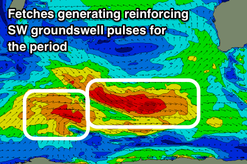
 E/NE offshores will kick in Friday across all locations (tending variable from the N/NE into the afternoon) as the first of two reinforcing SW groundswells fills in.
This first pulse has been generated by a great pre-frontal fetch of W/NW gales across the Heard Island region the last couple of days, with good 6ft+ sets expected to continue across swell magnets in the South West, 2-3ft in Mandurah and 2ft in Perth.
A secondary similar sized pulse of SW groundswell from post-frontal W/SW gales should fill in Saturday before easing through Sunday and Monday.
Winds look as if they'll remain favourable with light E/NE offshores on Saturday morning and weak sea breezes, fresher out of the E/SE all day on Sunday as a trough and high fill in from the south, more E/NE-NE on Monday.
Swell wise there's no new significant energy due until a strong but less than favourably structured polar low develops in the Heard Island region over the weekend.
We may see a moderate to possibly large long-period SW groundswell developing for Tuesday/Wednesday, but more on this Friday.


Comments
Good to see the South West solid and clean this morning..
It makes you home sick seeing such sickness I will be back once it cools down. I didn't know he was a gangsters and you think he would able to take a joke I sincerely apologized. I want to get back to making a name for myself surfing isolations!