A couple more doses of stormy swell before things settle down
Western Australia Surf Forecast by Craig Brokensha (issued Monday 6th August)
Best Days: Keen surfers eary Wednesday Mandurah and Perth, Friday morning Perth and Mandurah, all locations Saturday morning
Recap
XL stormy surf across all coasts on Saturday with good winds in protected spots for experienced surfers. The swell eased back into Sunday though, from a still large 10ft in the morning across the South West with better winds for protected spots, cross-offshore and much cleaner around Mandurah and Perth.
This morning the swell is smaller and weaker again with gusty onshore winds across the South West, cleaner and hanging in at 2-3ft around Mandurah, and 1-2ft in Perth.
Today’s Forecaster Notes are brought to you by Rip Curl
This week and weekend (Aug 7 – 12)
Want to receive an email when these Forecaster Notes are updated? Then log in here and update your preferences.
As pointed out last week, we're seeing a strong negative Southern Annular Mode bringing persistent mid-latitude fronts and onshore winds to our coast and this will continue most of this week.
Currently a strengthening system directly south-west of us is bringing increasing W/NW winds to the South West, kicking in through the afternoon across Mandurah and Perth.
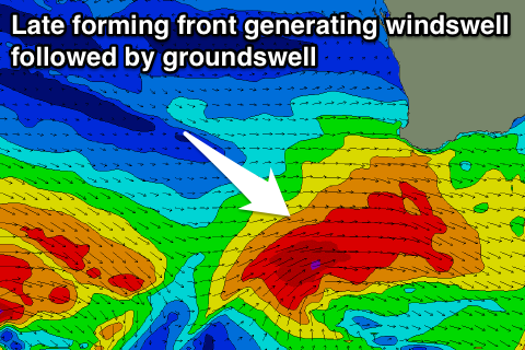
We'll see a fetch of W/SW gales produced late in our swell window, bringing an increase in windswell tomorrow with fresh to strong onshore W'ly winds.
Perth and Mandurah aren't expected to see too much size with the front being further south and local winds not being overly strong, with junky 2ft waves tomorrow, more 2-3ft early Wednesday across Mandurah before easing.
Margs looks to build to 6ft+ later tomorrow, peaking overnight to 6-8ft and then easing back from 6ft+ Wednesday morning but another mid-latitude front will bring fresh to strong W/NW tending NW winds. There's a chance that Mandurah and Perth will see early N/NE winds Wednesday morning creating workable conditions so keep an eye on the local wind observations.
 Thursday morning looks to reveal a mix of stormy NW windswell from the mid-latitude front and building SW groundswell from the earlier stages of the system. This system is currently north of Heard Island and will produce a small though persistent fetch of pre-frontal W/NW gales, followed by post-frontal severe-gales over the coming days.
A moderate to large SW groundswell is due off this front, but with the mix of W'ly windswell, our models are over-forecasting the size for Thursday.
We're looking at surf reaching 8ft on the sets through the day across Margs, with 3ft of NW windswell in Perth and Mandurah, replaced by 2-3ft of W/SW swell into the afternoon.
Strong NW tending SW winds will leave limited options for a decent wave, but into Friday winds will swing S/SE across Mandurah and Perth with a mix of swells easing from 2-3ft. Margs will be average with easing 6ft+ surf and small waves in protected spots under a S/SW breeze.
Saturday morning will finally see offshore winds across the South West out of the E/NE, but we'll be dealing with a weak easing mid-period swell from 4-5ft, 1-2ft further north.
Looking onwards from Sunday, it looks like we'll see one last burst of large onshore surf early next week before the pattern breaks down owing to the Long Wave Trough pushing further east and an upper level block moving in. This will see better conditions but on the downside, smaller swells. We'll have a closer look at this Wednesday though.

