XXL groundswell inbound for the weekend
Western Australia Surf Forecast by Craig Brokensha (issued Wednesday 25th July)
Best Days: Protected spots later tomorrow across the South West, likely Friday morning Perth and Mandurah, all coasts for experienced surfers Saturday, Monday
Recap
The South West remained extra-large and onshore yesterday, while unexpected lighter winds developed around Mandurah and Perth creating much better conditions with the swell easing back from the 3-4ft range.
This morning the surf was back to 8-10ft in the South West but with strengthening N/NW winds, workable around Perth and Mandurah early with N'ly breezes.
Today’s Forecaster Notes are brought to you by Rip Curl
This week and weekend (Jul 19 - 22)
Want to receive an email when these Forecaster Notes are updated? Then log in here and update your preferences.
Currently a strong mid-latitude front is approaching from the west, but the models have weakened this system as it crosses us, with the fetch of severe-gale to storm-force winds that were forecast now not likely.
Instead we'll see a weakening fetch of strong to gale-force SW winds moving across us this evening and tomorrow morning.
This will just create a poor low quality W/SW windswell, mixed in with some larger and stronger W/SW groundswell from the earlier stages of the front more so into the afternoon and Friday morning.
Margs looks to come in at a stormy 8ft tomorrow with strong but easing S/SW winds. With the W/SW swell strengthening through the afternoon we should see some decent options opening up for keen and experienced surfers.
Perth and Mandurah look to be around a stormy 3-4ft, easing through the day with those strong easing S/SW tending SW winds.
The window of lighter and more variable winds for Friday looks a little dicey, with onshore W/SW winds possibly still lingering across Mandurah and Perth. I feel we'll see the early variable winds though, with easing sets from 3ft across Mandurah and 2ft to maybe 3ft in Perth. Margs will remain poor and onshore with W/SW tending W/NW winds and easing 6-8ft surf.
 We then look ahead to the XXL long-period W/SW groundswell due on Saturday across the state.
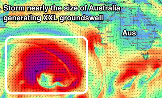
Currently a severe polar low has formed over the Heard Island region, generating a very expansive fetch of severe-gale to storm-force W/SW winds, with similar strength pre-frontal W/NW winds. The size of this storm is nearly as big as Australia, bigger than the previous system, but not maintaining its strength as long, resulting in a touch less size.
We'll see this low track slowly east this evening and tomorrow while weakening, producing an XXL long-period W/SW groundswell that will arrive overnight Friday and fill in rapidly Saturday.
A peak is expected into Saturday afternoon, with the swell being slightly undersized during the morning, and we can expect the South West to build to 15ft+ (larger at deepwater reefs), 4-5ft in Mandurah and 3-4ft in Perth.
Looking at the local winds, and we're expected to see a small high move in quickly from the west between fronts, resulting in variable winds across Margs, likely light SE tending E and then N, while Mandurah and Perth should see E/SE tending variable winds.
Hopefully this holds, but we'll have one final look at this on Friday.
Sunday will then become poor as the swell eases with an approaching mid-latitude front bringing strengthening W/NW winds, swinging SW with a change overnight.
Another moderate to large W/SW groundswell will fill in behind this front, but the window for clean conditions looks small and more so Monday afternoon for the South West, and most of the day Monday further north, but we'll review this Friday.

