Continuation of large windy surf
Western Australia Surf Forecast by Craig Brokensha (issued Monday 23rd July)
Best Days: Friday morning Perth and Mandurah, Saturday
Recap
Building onshore surf all weekend, becoming large later Saturday and through yesterday, while overnight one of the biggest swells in recent history hit the coast, with Cape Naturaliste peaking just under 10m, and 8m off Rottnest Island.
Surfing options have been limited to novelty super protected spots with gusty westerly winds.
Today’s Forecaster Notes are brought to you by Rip Curl
This week and weekend (Jul 24 – 29)
Want to receive an email when these Forecaster Notes are updated? Then log in here and update your preferences.
The broad and severe winter calibre frontal progression linked to today's XXL groundswell is still affecting our region, with a final trailing front currently clipping the south-west, producing a fetch of W/SW gales in our south-western swell window.
We'll see the easing trend slowed by this final front with Margs still expected to be around 15ft tomorrow morning, easing back to the large range on Wednesday. Perth looks to drop from 3-4ft with 4-5ft sets in Mandurah.
Our possible window of variable winds across Perth and Mandurah doesn't look likely at all, with fresh and gusty W'ly breezes, stronger across Margaret River and swinging W/NW through the day.
Wednesday will then be poor with strengthening N/NW winds ahead of an approaching mid-latitude front, possibly N'ly early around Perth and Mandurah but with strength.
The mid-latitude front will push across us Wednesday evening while strengthening, forming into a low and projecting a fetch of storm-force SW winds into the south-west tip of the state.
This will kick up another large stormy swell with severe winds overnight, easing back from the 12ft range across Margs Thursday morning, with 4ft surf in Mandurah, 3ft+ across Perth though with strong but easing SW winds.
Come Friday it looks like we'll finally see a window of cleaner conditions across Perth and Mandurah with a light morning E/NE breeze and easing 2ft+ and 2-3ft sets respectively.
Margs will remain onshore and from the W/NW, strengthening through the day as a weakening storm approaches from the west.
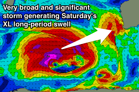
This storm will actually be very severe in its earlier stages, with it forming west of Heard Island this evening. We're due to see a pre-frontal fetch of severe-gale W/NW winds spawn into a much broader polar low. This will see storm-force W/NW winds followed by a broader storm-force W/SW fetch, projecting slowly east-southeast towards us through most of this week before breaking down Thursday evening.
An XL long-period W/SW groundswell will be generated, arriving late Friday though peaking through Saturday.
We're looking at powerful 15ft+ surf across Margs (larger deep water reefs), with 4-5ft sets in Mandurah and 3-4ft waves in Perth with what looks to be variable winds, light onshore across Margs.
The window again will be short as another front approaching from the west brings strengthening N/NW winds on Sunday, but we'll have a closer look at this in Wednesday's notes.


Comments
My goodness! It would be interesting to see dark point and those novelty spots like perth