Large to extra-large run of onshore surf
Western Australia Surf Forecast by Craig Brokensha (issued Friday 20th July)
Best Days: No good days, possibly Mandurah and Perth Tuesday morning and later week
Recap
Great waves across Perth and Mandurah yesterday with offshore winds and a drop in swell back to 3ft, clean most of the day. Margs improved but as expected, with the lack of strength in the offshore winds in the morning, conditions were quite lumpy and raw, bumpy into the afternoon as winds tended NE and freshened.
This morning Margs was much smaller and poor with a gusty N/NW wind, OK for keen surfers in Mandurah but best in Perth with clean easing surf from 2ft+.
Today’s Forecaster Notes are brought to you by Rip Curl
This weekend and next week (Jul 21 – 27)
Want to receive an email when these Forecaster Notes are updated? Then log in here and update your preferences.
Well, settle in for a long drawn out period of stormy large to extra-large surf with a strong node of the Long Wave Trough currently strengthening to our west, stalling through most of next week, directing front after front up towards and over us.
Already a mid-latitude low that developed south-east of Madagascar has pushed east and produced a large W/SW groundswell for tomorrow that will build through the day.
The remnants of this front will clip the state though, bringing fresh W/NW winds across all locations.
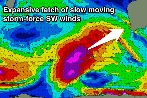
Of much greater significance is a very strong and expansive polar frontal progression that's already developed in the Heard Island region. A fetch of severe-gale SW winds have been generated, with this front stretching out and up towards us through this evening whil strengthening under the effects of the LWT.
 Expansive storm-force 50-55kt SW winds will be projected slowly on top of an active sea state, moving at a similar speed to the swell its producing, resulting in a captured fetch scenario.
With this we'll see larger and faster than normal wave growth, with an XXL long-period W/SW groundswell resulting, the largest of the season for Indonesia.
This XXL swell is due to start building Sunday though the front linked to it will slam into us at the same time, kicking up an XL increase in stormy W/SW swell along with strengthen W/NW winds, reaching gale-force later in the day.
Monday will be maxing across all locations as the XXL groundswell fills in, with 20-25ft surf across the South West 6ft+ in Mandurah and 4-5ft+ in Perth but with fresh and gusty W-W/SW winds.
The swell and winds are expected to settle down through Tuesday but with NW winds across the South West. Mandurah and Perth may see early light variable winds from the NE, but we'll have to review this again on Monday.
Into the second half of the week, more large groundswells are due, though not to the size or power as Monday's and with the LWT hanging in the region, the fronts linked to each swell will continue to push into us, bringing onshore winds (lighter around Perth and Mandurah)
We're not expected to see things settled down until next weekend, but more on this Monday. Have a great weekend!


Comments
I hope the Cape Nat bouy stays attached, how high can she go?
.