Small window to end the week, onshore weekend with XXL surf next week
Western Australia Surf Forecast by Craig Brokensha (issued Wednesday 11th July)
Best Days: Early Thursday all locations, possibly dawn Saturday in Mandurah and Perth, only the most experienced surfers on Tuesday
Recap
Great waves across the South West yesterday with a new long-period groundswell and all day offshores offering 4-5ft surf. Perth and Mandurah also saw good conditions all day with a bump in size to 1-2ft.
The swell was down just a touch this morning across the South West with good winds again, though this afternoon is average with sea breezes. Perth and Mandurah hung around 1-2ft with favourable winds.
Today’s Forecaster Notes are brought to you by Rip Curl
This week and weekend (Jul 12 - 15)
Want to receive an email when these Forecaster Notes are updated? Then log in here and update your preferences.
This afternoon a renewal of mid-period W/SW swell should be seen generated by a relatively weak but favourably aligned mid-latitude front earlier this week.
The swell is expected to peak early tomorrow offering 2ft sets in Mandurah and Perth with 4-5ft waves around Margs before easing slowly.
Our small window of early offshore winds is still on the cards, with a dawn E/NE breeze due across all locations, freshening from the N/NW mid-late morning, stronger from the NW into the afternoon as a vigorous mid-latitude low approaches from the west.
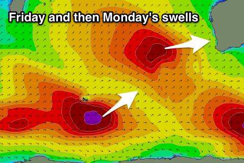
 The mid-latitude low is linked to an XL increase in W/SW groundswell on Friday, with it forming south-east of South Africa on Monday and since aimed a slow moving fetch of gale to severe-gale W/SW winds towards us through our western swell window.
An additional fetch of storm-force core winds will help push this swell into the XL size, building rapidly towards 10-12ft+, 3-5ft in Mandurah and 3-4ft across Perth into the afternoon. There'll also be a large S/SW groundswell from a polar low that formed south-southwest of us yesterday, but this will be hidden under the W/SW groundswell.
Winds will unfortunately be poor though and fresh and gusty from the W/SW as the low pushes across us.
We're still set to see onshore winds from the W/NW across the South West as the swell eases on Saturday, but the window of early variable winds for Perth and Mandurah still looks on the cards, giving into that W/NW onshore flow by mid-morning though. We'll have one last look at this on Friday though.
Size wise Mandurah should be easing back from 3-4ft and 3ft on the sets in Perth.
We'll continue to see wave heights ease through Sunday but with gusty SW winds as another front pushes up and into the state.
This front will be related to a new large pulse of SW groundswell for late in the day and more so Monday, with it spawning off the low linked to the swell.
The polar low has developed west of Heard Island and is generating a fetch of gale to severe-gale W/NW winds, tending more W/SW and weakening while moving east along the polar shelf.
A large long-period SW groundswell will result, peaking Monday morning to 8-10ft across the South West, 3ft in Mandurah and 2-3ft in Perth.
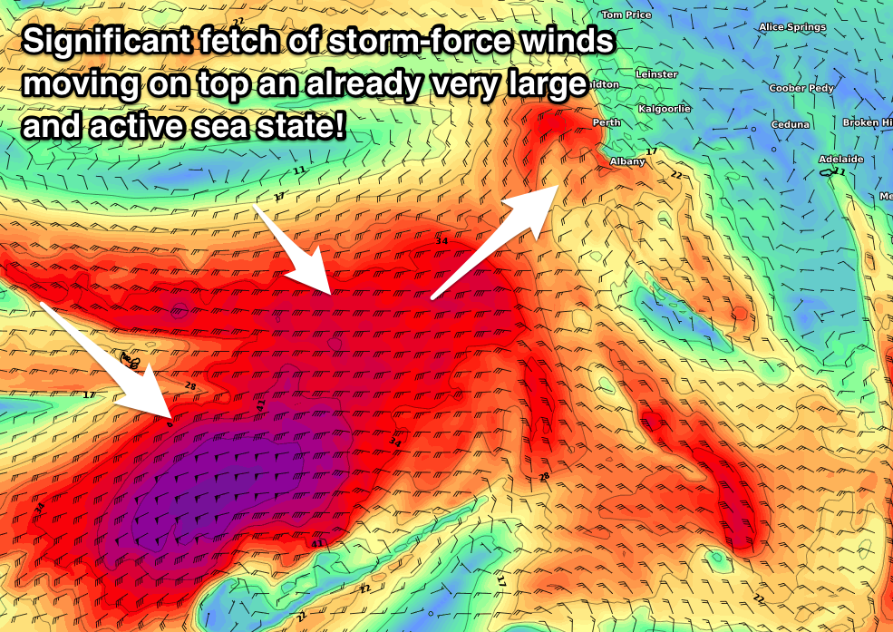
Before this swell gets a chance to ease some larger reinforcing SW groundswell is due to build on top of it later Monday and further Tuesday, with a third additional long-period XXL groundswell filling in through the day.
These additional swells will be generated by winter calibre polar frontal activity under the influence of a strong node of the Long Wave Trough.
A broad and elongated fetch of severe-gale W/NW winds will move over the active sea state generated by the low producing Monday's swell, with the fetch swinging more W/SW as the front starts tracing up towards us.
On the tail of this fetch an embedded and significant fetch of storm-force W/SW winds will slowly project up towards the south of the state from polar latitudes.
What we can expect is an initial increase in XL SW groundswell later Monday and Tuesday morning, with an XXL SW groundswell with a touch more south in it for Tuesday midday.
 Size wise Tuesday morning looks to come in at 12ft+ across the South West before jumping to 18-20ft rapidly through the morning, with larger sets at deepwater offshore reefs.
Mandurah looks to kick from 3-5ft to the 6ft+ range with building surf to 4-5ft in Perth.
The best thing about this progression is that a strong high will quickly move in from the west, swinging winds from W/SW-SW and then S/SW late Monday around to the E/SE tending E/NE Tuesday morning and NE into the afternoon.
This will create generally clean conditions across most locations with the dangerous mix of long-period groundswells.
This window will only be small with poor N/NW winds kicking in again as the swells ease Wednesday with another approaching front. We'll have to go over this all again on Friday though when the models will start locking down the track and strength of the incoming fronts.

