Good weekend of surf, deteriorating next week
Western Australia Surf Forecast by Craig Brokensha (issued Friday 1st June)
Best Days: Saturday all coasts (morning in the South West), Sunday, Monday morning
Recap
Poor conditions yesterday with strong onshore winds and building levels of windswell across all locations, while today winds swung offshore around Mandurah and Perth with great clean peaky 2-3ft waves, while more variable breezes provided fun options in protected spots across the South West.
Today’s Forecaster Notes are brought to you by Rip Curl
This week and weekend (Jun 2 - 8)
We've got a good weekend of surf due across all locations with favourable winds and a new SW groundswell.
Over the past couple of days a fetch of W/SW gales has projected from north-east of the Heard Island region, west towards us. This fetch is now slowly weakening, but we've got an elongated fetch of strong W/SW winds persisting in our swell window.
A moderate to large SW groundswell is due off the initial fetch, building tomorrow afternoon and easing Sunday, with this trend slowed into Monday by the tailing fetch.
 Margs should drop slightly into tomorrow morning, before building back to 6-8ft through the day, with 2-3ft waves in Mandurah and 2ft+ surf in Perth.
The swell is expected to ease from a similar size Sunday morning, back slowly from 5-6ft in the South West, 2ft+ in Mandurah and 2ft Perth through Monday.
Coming back to the local conditions and light E-E/NE winds are due across Mandurah and Perth tomorrow, variable into the afternoon, with the South West seeing E/NE-NE winds ahead of a shift to the W through the day.
Sunday looks better down across the South West with E/NE tending variable winds, similar to the north.
Monday should be clean early with variable winds early, increasing from the N/NE through the day as a vigorous mid-latitude storm approaches from the west.
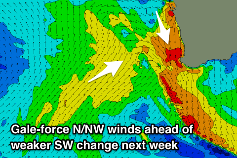
This mid-latitude cold outbreak doesn't look to bring much in the way of swell, with it not having much puff behind it, but it will bring a stormy N/NW windswell Tuesday morning with gale-force N/NW winds ahead of a weaker W/SW change through the day.
Unfortunately winds will remain onshore as the weak mid-period swell from the front peaks Wednesday, likely lingering onshore Thursday.
Longer term some larger long-period groundswell is due from next weekend, but winds look dicey. More on this Monday. Have a great weekend!


Comments
Yalls looking tidy this morning!

Yalls again! Stoked with the surfcam upgrade.. image quality is better with the new cam and the stream quality is better with the NBN connection.

Gosh its a Nice....Wave!