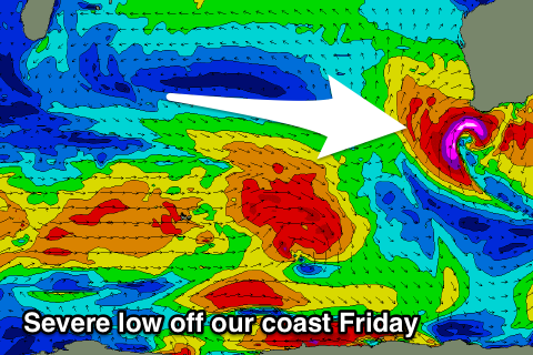
Strengthening onshore winds and building storm surf
Western Australia Surf Forecast by Craig Brokensha (issued Wednesday 23rd May)
Best Days: Dawn Thursday, later Monday and Tuesday morning
Recap
A fun increase in W/SW swell to 3-4ft with morning offshores across the South West yesterday morning, and 1-1.5ft waves to the north.
This morning we've seen the best pulse of swell peak with good sets to5- 6ft across the South West and workable early winds, clean and 2ft+ around Perth and Mandurah.
Today’s Forecaster Notes are brought to you by Rip Curl
This week and weekend (May 24 – 27)
Make the most of the current waves and weather as we're in for large cold stormy conditions from later tomorrow and more so Friday.
We'll see smaller leftover W/SW swell across the South West tomorrow morning to 4ft, 1-1.5ft in Perth and Mandurah along with a dawn N/NE-NE breeze, fresh and tending N'th by mid-morning, strong into the afternoon, kicking up a building N/NW windswell.
Moving into Friday and a severe low is forecast to develop off the South West with a ftech of severe-gale to storm-force W/SW winds forming through the day.
This will kick up a large stormy SW swell through the afternoon along with strong to gale-force W/NW tending W/SW winds.
Perth and Mandurah look to come in at 3-4ft, while Margs is likely to build to 10ft+ through the day.
 The low will remain strong into Friday evening pushing east through Saturday with XL easing stormy surf from 12-15ft along with strong W/SW winds and easing 3-4ft waves in Perth and Mandurah.
The surf will remain large and messy on Sunday with the arrival of a new long-period SW groundswell from a more distant polar fetch of severe-gale to storm-force winds. Conditions will remain poor though with strong W'ly winds.
More large long-period SW groundswell energy is due Tuesday, generated by patchy though strong fetches through the Southern Ocean, but ahead of this a strong front pushing into us Monday will kick up more large windswell.
As touched on Monday though, a small high is expected to move in from the west Monday evening, bringing offshore E/NE winds on Tuesday morning and the long-period swell energy.
We're probably looking at easing 8-10ft surf in the South West and 2-3ft waves further north, but more on this Friday.


Comments
Hooray finally some storm action to shift the banks!
Yeah this will def stir things up.