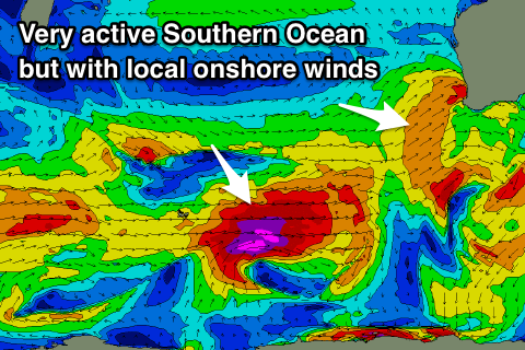
Large developing surf with onshore winds
Western Australia Surf Forecast by Craig Brokensha (issued Monday 21st May)
Best Days: Spots that handle north-east winds early tomorrow and early Wednesday
Recap
Clean fun waves across the South West magnets to 3-4ft Saturday, back to 2-3ft Sunday. This morning we've had another small spike in swell back across Margs and 1ft in Perth and Mandurah, with a little more size this afternoon across the South West.
Today’s Forecaster Notes are brought to you by Rip Curl
This week and weekend (May 22 – 27)
This afternoon's small spike in W/SW swell should be replaced by a better long-period W/SW groundswell later tomorrow, peaking early Wednesday.
The swell was generated by a tight and intense fetch of severe-gale to storm-force W/SW winds being projected towards us from south-east of Madagascar.
The swell should kick to 4-5ft+ by dark across the South West and 1-2ft on dark in Perth and Mandurah, easing from 4-6ft and 2ft respectively Wednesday morning.
 Winds will be a bit of an issue, dawn NE winds will swing more N/NE and freshen through the morning tomorrow, swinging N-N/NW into the afternoon, following a similar but faster pattern through Wednesday which isn't great at all.
Thursday as the W/SW swell eases will become poor with fresh N/NE winds, strengthening from the N/NW into the afternoon as a vigorous mid-latitude front approaches from the west.
The front will be the remnants of a strong storm that's developing around Kerguelen Island and will project a fetch of gale to severe-gale W/SW winds towards us before breaking down on Wednesday.
A good new W/SW groundswell will be generated for Friday, but at the same time the front will push across us bringing strong to gale-force onshore W/SW winds and an increase in low quality stormy W/SW swell.
Secondary fronts will project up and into us through through the weekend and early next week all owing to a strong node of the Long Wave Trough developing to our west and sliding across us before stalling.
This will bring large - extra large stormy surf Saturday through early next week with poor onshore winds.
Some good quality groundswells will be spoilt by the local conditions as well, produced by stronger more distant storms to our south-west.
There's a chance we may see a high slide in Tuesday bringing offshore winds to all locations along with a large easing SW groundswell from the 10ft range, but we'll have to have a closer look at this on Wednesday.

