Building SW swell Sunday, best Monday morning with a larger SW groundswell mid-week
Western Australia Surf Forecast by Craig Brokensha (issued Friday 4th May)
Best Days: Swell magnets across the South West tomorrow morning, Monday morning, Wednesday, Thursday morning
Recap
Large onshore waves across the South West yesterday morning, fun in protected spots while Perth and Mandurah saw early light winds and fun 2-3ft sets.
This morning conditions were a touch cleaner but far from perfect across the South West with a variable offshore wind and smaller 4-5ft sets. Mandurah and Perth were better with offshore winds and 2ft waves on the former, 1-2ft latter.
Today’s Forecaster Notes are brought to you by Rip Curl
This weekend and next week (May 5 - 11)
We're looking at nice clean conditions across all locations tomorrow morning with a moderate to fresh E/NE breeze, swinging more NE late morning and N/NE into the afternoon.
There isn't due to be any major swell though with leftover 3ft to maybe 4ft sets across the South West, tiny to the north.
Our new SW groundswell energy for Sunday and Monday is still on track, with a flurry of unconsolidated but good looking frontal systems moving through our south-western swell window.
 There'll also be some junky NW windswell in the mix mainly noticeable across Perth and Mandurah on Sunday as a strong mid-latitude low moves across us. This low will bring strengthening N/NW tending NW winds, shifting strong SW through the afternoon.
Size wise the SW groundswell should build towards 6ft+ later in the day across the South West, peaking Monday morning to 6ft to possibly 8ft. Perth and Mandurah will see building levels of NW windswell to a stormy 2-3ft through Sunday, with the groundswell for Monday morning coming in at 2-3ft around Mandurah and 2ft in Perth.
Winds are looking excellent Monday morning as the mid-latitude low clears to the east resulting in straight light offshore E'ly winds across all locations ahead of afternoon sea breezes.
Tuesday will be smaller and a weak trough looks to bring less favourable S/SW breezes to the South West, possibly S/SE early to the north.
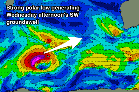
Our next swell will be a long-period number and large, produced by strong polar low developing west of Heard Island this evening. A tight fetch of severe-gale to storm-force W/SW winds will be projected towards us over the weekend, continuing east through early next week.
This should produce a large long-period SW groundswell for Wednesday, building rapidly through the day and reaching a large 8-10ft by dark across the South West, 3ft in Mandurah and 2-3ft in Perth.
Winds at this stage look favourable and from the E/SE tending SE, but we'll have to review this again on Monday. Beyond this swell, further polar frontal activity looks to generate more size late week, but more on this Monday. Have a great weekend!

