Building surf with onshore winds, cleaner and easing late week and large surf from Sunday
Western Australia Surf Forecast by Craig Brokensha (issued Monday 30th April)
Best Days: Perth and Mandurah Thursday morning, early Friday South West, Saturday morning and early Sunday in the South West
Recap
Epic waves Saturday with an oversized clean SW groundswell coming in at 10-12ft+ across the South West, 3-4ft in Mandurah and 2-3ft Perth. Winds remained favourable all day with the swell backing off later in the day.
Sunday was half the size and clean early before winds shifted to the north, while today we're back to small to tiny surf with deteriorating conditions.


Today’s Forecaster Notes are brought to you by Rip Curl
This week and weekend (May 1 - 6)
The next couple of days aren't too flash with onshore winds and a mix of building weak mid-period W/SW swell tomorrow, with some slightly stronger groundswell Wednesday.
The mid-period swell has been produced by the weakening mid-latitude low that's currently pushing into us, with no decent size expected through tomorrow, along with fresh SW winds.
Perth and Mandurah will likely see winds tend S/SE through the morning with building surf to 2ft across the later, and 1-2ft in Perth during the day. This will likely be once winds swing back onshore, so it probably won't be worth an early.
Wednesday will see more distant W/SW groundswell fill in, but this now looks to be overshadowed by a local increase in SW tending S/SW swell, generated by a vigorous polar front projecting up and into the south-west of the state.
A fetch of SW gales will be produced right off the corner of the state, kicking up a stormy increase in SW swell Wednesday afternoon to 6ft+ by dark though with strong SW winds.
Perth and Mandurah look to build to a stormy 2-3ft, with a stronger S/SW groundswell due Thursday morning.
Margs should see 6-8ft sets across exposed breaks to the south swell, easing during the day, and 2-3ft waves in Mandurah, 2ft+ in Perth.
Unfortunately a secondary weaker front pushing in behind the storm on Wednesday will keep onshore SW tending W winds blowing across the South West Thursday but Perth and Mandurah should see a morning offshore and weak sea breezes.
A very short window of lighter N/NE winds is expected Friday morning across the South West before shifting NW ahead of another front clipping the state.
The swell will be smaller but still solid across the South West as some less consistent long-period S/SW energy fills in, produced by the early stages of the polar front projecting towards us tomorrow and Wednesday.
Magnets across Margs are due to offer 4-6ft sets, easing through the day, while Mandurah and Perth look small to tiny.
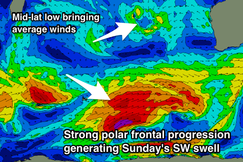
 Over the weekend we've got some good new long-period SW groundswell on the cards, produced by strong and slow moving polar frontal progression that will develop in the Heard Island region Wednesday.
An initial weak fetch of strong to gale-force W/SW winds will pave the way for a better fetch of severe-gale W/SW winds, projecting east-northeast towards us, generating a large SW groundswell Sunday afternoon.
We should see an increase in size later Saturday, with Sunday building to 8ft+ on the sets across the South West, with a possible secondary large long-period swell for Monday.
Unfortunately a weak mid-latitude low moving in from the west looks to bring NE tending NW winds on Sunday, persisting from the N/NW Monday, but we'll confirm this Wednesday.

