Fun waves from Sunday, outside chance for cyclone swell next weekend
Western Australia Surf Forecast by Craig Brokensha (issued Friday 16th March)
Best Days: Sunday morning all locations, Monday morning through Thursday morning at South West swell magnets
Recap
Onshore winds and small surf in the South West, tiny to the north yesterday.
This morning a new SW swell has provided a bit more action across all coasts with light winds and glassy 3-4ft sets off Margs, 1-2ft waves in Mandurah, tiny around Perth.
Today’s Forecaster Notes are brought to you by Rip Curl
This weekend and next week (Mar 17 – 23)
The weekend outlook hasn’t changed much from Wednesday with poor conditions and a building windswell tomorrow, followed by stronger levels of groundswell with offshore winds Sunday.
A relatively weak polar front is currently projecting towards us and will push through tomorrow, with gusty SW tending S/SW winds expected across all locations tomorrow with a building windswell.
Come Sunday we'll see groundswell from the earlier stages of the polar front filling in, building to 5-6ft through Sunday, with possibly the odd bigger one in the mix through the afternoon at its peak.
Mandurah should see fun sets in the 2ft+ range, with slow 1-2ft waves in Perth.
 Winds will swing offshore as a high moves in though, with E/SE breezes expected across all locations Sunday morning ahead of sea breezes.
We'll see the surf easing through next week with favourable conditions continuing right until Friday.
Morning E/SE winds are due to develop Monday with easing 4-5ft sets in the South West, tiny to the north. Better E'ly offshores are then due Tuesday, Wednesday and Thursday.
The strong polar activity forming late in our swell window providing S/SW groundswell energy mid-week now looks to form a little to far east to generate any size at all.
Margs may see a little uptick in size later Tuesday and more so Wednesday morning to 3-4ft across spots exposed to the south swell, easing through the day.
Longer term we've got some interesting developments on the cards.
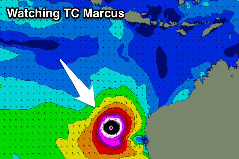
Tropical Cyclone Marcus has just formed off northern Australia, north-east of Darwin.
Current forecasts have TC Marcus tracking west-southwest through the weekend and early next week to a position about half way between Exmouth and Java.
From here we could see Marcus heading south down along our coast, bringing some rare NW groundswell, but ECMWF has Marcus breaking down in the Indian Ocean well west of us.
In any case this will be one to watch. Have a great weekend!

