Slow week, fun weekend
Western Australia Surf Forecast by Craig Brokensha (issued Monday 5th March)
Best Days: Desperate surfers South West magnets tomorrow morning, Saturday and Sunday across the South West
Recap
Great waves Saturday morning with a reinforcing swell to 4-5ft and offshore winds across the South West, only 1-1.5ft in Mandurah and 1ft Perth.
Sunday was small across the South West and tiny to the north with straighter offshore winds.
This morning there's hardly any swell left across the coast at all with clean small 2ft waves across the South West magnets.
Today’s Forecaster Notes are brought to you by Rip Curl
This week and weekend (Mar 6 – 11)
Tomorrow will remain small to tiny, with a distant background SW groundswell due to provide infrequent 2-3ft sets across the South West, tiny to the north. Early will be cleanest with a E/NE tending NE breeze N/NE into the afternoon ahead of a late N/NW change as a small trough moves in from the west.
This trough will bring onshore W/SW-SW winds Wednesday with small fading levels of swell, with no new energy due until later in the week and more so Saturday.
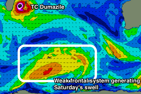
This will be a small-moderate sized SW groundswell, generated by a broad and slow moving polar frontal system from west of Heard Island, up towards us over the coming days.
Wind speeds will only be strong to gale-force, but we should still see a fun increase in size for the weekend.
A small mid-period increase is due later Friday to 3ft+ across the South West, with no size to the north, with the best pulse of swell for Saturday coming in around 4-5ft, with 1-1.5ft sets in Mandurah, 1ft Perth.
 Winds on Friday will be from the S/SE with strong SE-E/SE winds Saturday morning, E/SE Sunday as the swell eases.
The strength of these offshore winds might create a few problems so stick to more protected spots closer to shore.
Into next week we'll see the surf really drop back again with no significant size due at all.
The Southern Ocean storm track will fire up under SA and Vic, but be too far east to generate any swell for us.
Tropical Cyclone Dumazile which is currently sitting off the Madagascar coast isn't due to generate any significant swell for us, with most of the swell energy being aimed west into South Africa.
More on this and the longer term outlook Wednesday.

