Building swell pulses, best in the South West
Western Australia Surf Forecast by Craig Brokensha (issued Monday 22nd January)
Best Days: Margs Tuesday and Wednesday mornings, Mandurah Wednesday morning, Sunday morning in the South West
Recap
Fun waves across magnets in the South West Saturday with clean surf in the 4ft range, 1-1.5ft around Mandurah and 1ft in Perth.
A new S/SW swell filled in yesterday though S/SE winds limited surfing options.
The swell was cleaner today but on the ease with workable 4ft waves in the South West and 1-1.5ft in Mandurah and Perth.
Today’s Forecaster Notes are brought to you by Rip Curl
This week and weekend (Jan 23 - 28)
The swell should slowly increase through tomorrow and Wednesday, owing to the arrival of two new SW groundswells.
These swells have been created by the same weather system, that being a strong polar low that developed west of the Heard Island region, before weakening slightly and racing ahead of the original swell it produced, projecting up towards us and the Bight, generating an additional closer-range SW swell.
We'll see a good increase in SW groundswell tomorrow, peaking into the afternoon with the most consistency, generated by the secondary stages of the storm.
 Wednesday will then see less consistent long-range energy filling in, peaking through the afternoon also.
Margs is expected to reach 4-5ft+ into tomorrow afternoon with 1ft to maybe 2ft sets in Manudrah, 1ft+ in Perth. A morning SE breeze will favour most spots, strengthening from the S/SE in the South West, with sea breezes to the north.
Wednesday morning looks to come in a touch under Tuesday afternoon's peak, but into the afternoon we should see inconsistent 6ft sets on the South West magnets, 1-1.5ft in Mandurah and 1ft in Perth. Winds look similar with morning SE offshores, changing into the afternoon.
The swell should start to ease from Thursday and winds look to shift from S/SE to SW as a weak front approaches from the south-west.
This front will be slow moving but weak, bringing a small increase in mid-period SW swell through the weekend, building Saturday and peaking Sunday morning.
Before this though we'll see onshore winds persisting Friday and Saturday, improving as the swell peaks Sunday morning. We're probably looking at surf peaking around 4-5ft+ across the South West, tiny to the north, but more on this Wednesday.
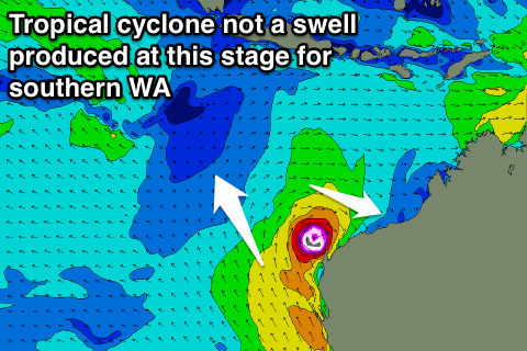
Also worth tracking is tropical developments off our North West later this week. An active Madden Julian Oscillation and monsoon trough across northern Australia look to result in the formation of a tropical cyclone which will drift south-southwest towards Exmouth. At this stage this cyclone looks to weaken without generating any decent swell for our main forecast regions, but check back here on Wednesday for an update on this.

