Not the greatest week, more significant developments next week
Western Australia Surf Forecast by Craig Brokensha (issued Monday 8th January)
Best Days: Tuesday morning and early Wednesday across the South West and Mandurah, Saturday and Sunday across South West swell magnets, early next week
Recap
A building onshore stormy swell through Friday afternoon and evening held size into Saturday across all locations with easing 6ft+ surf in the South West, 2-3ft in Mandurah and 1-2ft around Perth. Conditions were cleanest in protected spots across the South West and better to the north.
Sunday was half the size but cleaner across the South West with a better morning SE breeze. Today was smaller again with less than ideal S/SE winds across the South West, tiny and cleaner to the north.
Today’s Forecaster Notes are brought to you by Rip Curl
This week and weekend (Jan 9 - 14)
Over the coming week we've got some fun SW groundswell pulses due, generated by persistent but relatively weak frontal activity through our swell windows.
Two separate increases are due tomorrow, the first from a polar front on Saturday, while a secondary pulse for the afternoon/evening was generated last night by a front directly south-west of us.
We should see Margs building to 4-6ft through the afternoon with 1-2ft sets around Mandurah but only tiny in Perth, easing from a slightly smaller range Tuesday morning.
Conditions tomorrow morning as the swell builds look great with SE tending E/SE winds, giving into afternoon sea breezes, while Wednesday will see winds revert back to a S/SE tending SW pattern.
This is due to a weakening front pushing up towards us mid-week and will maintain onshore winds through Thursday from the SW as our strongest pulse of swell fills in.
This will be generated by the initial stages of the front at polar latitudes south-west of us yesterday and today.
We should see a good sized SW groundswell arriving overnight Wednesday and peaking Thursday morning to a good 5-6ft across the South West, 2ft around Mandurah and 1-1.5ft Perth.
The swell will ease Friday and winds still may be dicey across the South West and out of the S-SW, but likely S/SE, while Mandurah and Perth look cleaner but they'll be tiny.
 Cleaner conditions will be seen over the weekend but with no significant new swell.
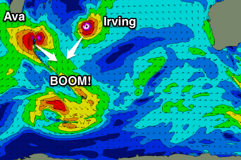
Of much greater importance is some exciting developments in the Indian Ocean.
Tropical cyclone Ava which is currently sitting off the Madagascar coast will drift south-east while at the same time tropical cyclone Irving which is current west-southwest of the Cocos Islands drifts south.
Both will merge towards each other while entering the Southern Ocean combining and turning into one large and severe "bombing low" north of the Heard Island region.
A bombing low needs surface pressure to drop more than 24hPa in 24 hours and we'll see these systems clearly meet that prerequisite.
 We're set to see an initial fetch of storm to hurricane-force W-W/NW winds projected through our western swell window as the low moves slowly east-southeast while weakening.
A large long-period W/SW groundswell is due, with 25s forerunners expected to arrive later Sunday ahead of the groundswell proper Monday, peaking later in the day.
At this early stage the South West looks to peak around the 12-15ft range with 3-4ft sets in Mandurah and 2-3ft waves in Perth. Morning offshores will give into afternoon sea breezes, but more on this Wednesday.


Comments
How confident are you about that "bomb" Craig ? Should I dust off the big board ?
Confident enough to get the big boards ready. Size could shift a little so we'll see what the coming days bring.
wams are impressive
Looks like I've picked the wrong time to go fishing.