Fun waves across magnets from Thursday
Western Australia Surf Forecast by Craig Brokensha (issued Monday 4th December)
Best Days: Swell magnets across the South West Thursday, Friday, Saturday and Sunday mornings
Recap
No swell on Saturday, while a small new SW swell built through yesterday across the South West, with winds hanging in there until mid-afternoon. Perth and Mandurah remained tiny.
Today conditions improved through the day with a developing offshore wind and small inconsistent surf in the 3ft range across the South West, tiny to the north.
Today’s Forecaster Notes are brought to you by Rip Curl
This week and weekend (Dec 5 - 10)
Today's small SW swell is expected to fade overnight, with a low point in energy tomorrow morning with less than ideal S/SE tending S/SW winds.
Into the afternoon some new background SW groundswell is due to fill in, followed by now a slightly better pulse Wednesday afternoon and Thursday morning.
The background energy is from weak polar frontal activity in the Southern Ocean, with only small and inconsistent 3-4ft sets due across swell magnets later tomorrow and Wednesday morning. Perth and Mandurah will be lucky to reach 0.5ft.
 The better swell for later Wednesday and Thursday morning is being generated by a weak front that's currently projecting towards us from the south-west.
Better sets to to 4-5ft likely across the South West, but only to 1ft or so around Mandurah and Perth.
Winds will remain less than ideal Wednesday and from the S/SE, but Thursday morning is the pick with a straight offshore E/SE breeze before sea breezes kick in.
Friday is also clean but the surf looks smaller and back to 3-4ft across the South West.
Over the weekend the surf will continue to ease before a new long-period and very inconsistent SW groundswell fills in Saturday afternoon, peaking Sunday morning.
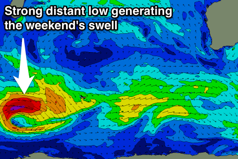
This swell is being generated by a small tight but intense low that's currently west of Heard Island, generating a fetch of severe-gale to storm-force W/SW winds.
We're looking at a peak to a very inconsistent 4-6ft across the South West, with 1-1.5ft waves further north and winds look offshore Sunday morning.
Longer term there's still nothing major on the cards until mid-late next week when we may see some better SW groundswell developing, but more on this Wednesday.

