Poor outlook ahead
Western Australia Surf Forecast by Craig Brokensha (issued Wednesday 29th November)
Best Days: Swell magnets Friday morning across the South West, similar Monday morning
Recap
Poor conditions yesterday and this morning with small amounts of swell in the South West and tiny surf to the north along with more favourable winds.
Today’s Forecaster Notes are brought to you by Rip Curl
This week and weekend (Nov 30 – Dec 3)
The current onshore winds across the South West are linked to a weak polar front projecting up and under our South Coast, with a small mid-period increase in SW swell due later today, peaking tomorrow morning and easing through the day.
Margs should come in around 4ft across exposed breaks tomorrow morning, easing through the day, smaller and 2-3ft Friday morning.
Perth and Mandurah are due to remain tiny, becoming near flat through Friday and Saturday.
Winds tomorrow are less than ideal with E/SE offshores around Perth and Mandurah, but S/SE breezes around Margs.
Friday will be much cleaner with an E'ly offshore down South, but the swell only small, weak and fading with tiny clean surf Saturday.
Looking longer term and there outlook is still rather grim, with no significant or favourably aligned storms developing in our swell window.
 A pre and post-frontal fetch of NW and SW winds through our swell window late week should produce a small SW for later Sunday and Monday morning but hardly above 3ft across South West magnets, tiny to the north.
Winds look favourable each morning ahead of sea breezes.
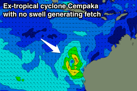
Looking at tropical cyclone Cempaka which has formed off the Indonesian coast, we'll see this cyclone drift south towards our north-west during the coming days while weakening, with no swell at all due to be generated in our swell windows.
Longer term similar small pulses of swell are due through next week, with decent winds, but more on this Friday.

