Average weekend, good SW swell energy early-mid next week
Western Australia Surf Forecast by Craig Brokensha (issued Friday 17th November)
Best Days: Sunday morning in the South West, Tuesday morning protected spots, Wednesday morning, Thursday morning swell magnets in the South West
Recap
Very small waves across the South West yesterday with good offshore winds, tiny to flat to the north.
Today a slight lift in new SW swell has been seen across the South West though with a moderate onshore wind, similar to the north but only tiny.
Today’s Forecaster Notes are brought to you by Rip Curl
This weekend and next week (Nov 18 - 24)
Today's new SW groundswell will fade back into tomorrow, with a small increase in mid-period W/SW swell through the afternoon, generated by a weak trough projecting towards us the last couple of days.
The South West should hold around the 4ft range, with tiny 1-1.5ft surf building around Perth and Mandurah. Winds are still dicey with a dawn variable breeze across the South West, giving into a mid-morning S/SW change, while Perth and Mandurah look poor all day with W/NW tending S/SW winds.
 Sunday should be cleaner with a variable breeze due across all locations again but with small easing 3-4ft waves across the South West and 1ft sets to the north.
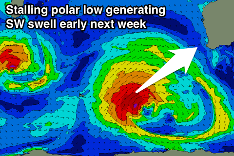
Our new prolonged SW groundswell event for early next week is still on track, with a strong and stalling polar low due to develop between us and Heard Island through today and tomorrow.
We'll see an initial fetch of W/SW gales generating a fun SW groundswell pulse for Monday, building through the day, with a secondary fetch of slightly stronger gale to severe-gale SW winds wrapping around on top of the active sea state.
This should generate a larger SW groundswell for Tuesday, peaking through the morning.
Monday should see surf building to 5-6ft through the day across the South West, smaller early and 1-2ft sets into the afternoon in Perth and Mandurah.
Larger surf to 8ft is expected on Tuesday across the South West and 2-3ft in Mandurah, 2ft+ in Perth ahead of an easing trend late in the day, more so Wednesday.
Winds are looking average Monday as a weak front spawning off the storm brings NW tending SW winds across all locations, while Tuesday is looking better but not ideal with morning S/SE winds and afternoon sea breezes.
Wednesday looks cleanest with a straight offshore E'ly wind, similar Thursday morning though the surf will be small by then.
There's no significant swells due into the end of the week or next weekend at this stage, so make the most of the surf from Tuesday. Have a great weekend!

