Fun swells over the coming days with workable winds
Western Australia Surf Forecast by Craig Brokensha (issued Friday 10th November)
Best Days:
Recap
Good fun waves yesterday morning across all locations with a new W/SW groundswell to 6ft on the sets across the South West and 2ft around Perth and Mandurah.
This morning the swell had dropped back to a smaller 3-4ft around Margs and an inconsistent 2ft around Mandurah and 1-2ft in Perth with variable winds.
This weekend and next week (Nov 11 - 17)
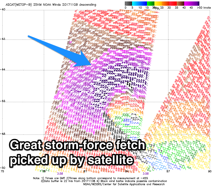
 Satellite observations have come in regarding the low linked to tomorrow's strong pulse of W/SW groundswell and it's looking good. Storm-force winds have been picked up and we should see this long-period W/SW groundswell arriving overnight and peaking tomorrow morning to a strong 6ft around Margs and 2ft+ further north.
Conditions are looking a little better tomorrow morning now with a SE breeze likely across the South West and E/NE winds further north before sea breezes kick in.
A temporarily drop in swell is expected into Sunday morning ahead of our reinforcing SW swell into the afternoon, holding Monday.
The swell is being generated by a broad polar front that's currently north-east of the Heard Island region and while not as strong as the low, it is much greater in expanse and longer-lived.
The swell should build back to 5-6ft across the South West later Sunday and hold through Monday with 2ft sets around Mandurah and Perth. A slow drop in size is expected through Tuesday, further through Wednesday and Thursday ahead of a small new SW swell for Friday.
Coming back to the winds and Sunday will see fresh to strong S/SE winds across the South West, more SE to the north favouring protected spots.
A touch more SE is likely in the winds on Monday morning, while Tuesday looks cleanest across exposed breaks though a bit bumpy with stiff gusty SE-E/SE winds.
A swing in winds to the E/NE is due Wednesday favouring swell magnets across the South West as the surf fades.
Friday's swell will be generated by a relatively weak polar low forming to our south-west early next week. We may see sets to 4-5ft across the South West, with 1-1.5ft waves to the north though with possible onshore winds as a trough moves in from the west, but more on this Monday. Have a great weekend!

