Improving conditions over the weekend with a new S/SW swell
Western Australia Surf Forecast by Craig Brokensha (issued Friday 29th September)
Best Days: Saturday both coasts, Sunday in the South West, Monday morning in the South West, Wednesday both coasts
Recap
Average conditions across the South West yesterday while Perth and Mandurah were cleaner as the swell dropped back to the 2t range on the sets.
A slight lift in S/SW swell has been seen today with offshore winds again across Perth and Mandurah, with poor gusty S'ly winds around Margs.
This weekend and next week (Sep 30 – Oct 6)
Conditions will finally improve over the weekend as a ridge of high pressure moves in from the west, swinging winds offshore from the E/SE across all locations tomorrow morning.
A new S/SW groundswell is due, but the size has been downgraded a touch with the strong polar low generating it not reaching any major strength within our swell window.
We should see 4-5ft+ waves across the South West tomorrow, easing back a touch into Sunday.
Mandurah only looks to come in at 1-2ft, with 1-1.5ft waves to the north, easing into Sunday. E/NE winds will kick in Sunday morning, tending NE through the day before going variable into the afternoon.
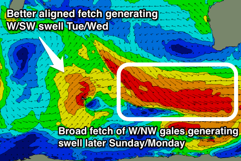
 Later Sunday some new SW groundswell is expected of a great broad fetch of W/NW gales stretching out through our south-western swell window this evening and tomorrow.
While not greatly aligned, we should still see some fun energy spreading up towards us from this fetch, kicking later Sunday and peaking Monday afternoon.
Margs should see 3-5ft surf, becoming a little more consistent in that upper range into the afternoon, while Perth and Mandurah aren't likely to top 1-1.5ft.
Winds on Monday morning are a little dicey but should be variable creating clean conditions ahead of a W'ly change as a weakening front moves in from the west.
This front will generate a new mid-period W/SW swell for Tuesday, building through the day and peaking overnight.
Margs looks to build to 6ft on the sets later in the day, easing from 5-6ft Wednesday morning, while Mandurah should see fun 2ft+ sets, 2ft around Perth.
A ridge of high pressure will start moving in Tuesday but conditions look average with gusty S/SE winds, while a better SE offshore is expected on Wednesday.
Longer term we may see a fun SW groundswell for next weekend, followed by a slightly larger pulse the following week with favourable winds, but more on this Monday. Have a great weekend!

