Nothing special to end the week, fun weekend
Western Australia Surf Forecast by Craig Brokensha (issued Wednesday 27th September)
Best Days: Perth and Mandurah Thursday morning and Saturday morning, Margs Saturday morning, Sunday, Monday morning
Recap
Some good W/SW swell yesterday morning came in unchecked with 2-3ft sets around Perth and Mandurah along with offshore winds, while Margs saw a bit more size though conditions were average with a gusty S'ly wind.
Today the swell has dropped back temporarily and conditions are average across the South West with early offshores to the north. We should see a new inconsistent SW groundswell this afternoon reaching 4-6ft across the South West and keeping 1-2ft waves hitting Perth and Mandurah though with onshore winds.
This week and weekend (Sep 27 – Oct 1)
This afternoon's increase in SW swell is expected to ease back a touch into tomorrow morning leaving 4-5ft sets across the South West and 1-2ft waves in Perth and Mandurah. Winds are looking a little average across the South West as a trough moves in from the west bringing S/SE breezes, straighter offshore around Mandurah and Perth.
A new mid-period S/SW swell is expected on Friday, generated by a broad but relatively weak polar front projecting from below us up towards the south-east of the country.
No major size is due with 4-5ft sets across the South West and 1-1.5ft waves further north along with lingering S/SE winds (more SE around Perth).
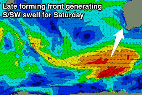
 Our stronger S/SW groundswell for Saturday is still on track, with a good looking polar front due to develop east of Heard Island this afternoon/evening, generating a broad fetch of W/SW gales late in our southern swell window.
This swell looks to come in around the 6ft range on the sets across the South West with 1-2ft waves further north, easing into the afternoon and further Sunday.
Winds are looking much better for the weekend with a morning E/SE offshore Saturday and E/NE tending NE and then variable winds Sunday.
Into later Sunday and more so Monday some fun reinforcing SW groundswell is due off a secondary poorly aimed but broad fetch of strong to gale-force W/NW winds behind the initial strong polar front.
This should keep the South West up around 3-5ft through Monday and Tuesday, tiny to the north and with morning offshores on the former and gusty S/SE winds Tuesday/Wednesday.
Longer term we may be looking at a larger SW groundswell developing for next weekend, but with onshore winds, more on this Friday though.

