Easing surf with clean conditions
Western Australia Surf Forecast by Craig Brokensha (issued Friday 1st September)
Best Days: Swell magnets all week across the South West, tomorrow morning Perth and Mandurah
Recap
Large and onshore across the South West Saturday, a bit smaller and still poor Sunday.
Mandurah saw pumping clean 3-4ft waves on Saturday (2-3ft on the sets around Perth) and back to the smaller 2ft range Sunday.
Today a large new long-period S/SW groundswell was a little delayed in arrival this morning but came in strong mid-morning with large clean sets in the 8ft range across the South West before sea breezes kicked in. Mandurah and Perth also started slow but kicked as winds have remained light.


This week and weekend (Sep 5 - 8)
Today's strong long-period S/SW groundswell should peak this afternoon, and ease back steadily through tomorrow, down further into Wednesday.
Conditions will be great again tomorrow morning with an E-E/NE offshore wind ahead of afternoon sea breezes and easing sets from the 6ft range in the South West and 2ft further north.
 Wednesday looks clean again with a morning E/SE offshore but the swell will be tiny around Perth and around 3-4ft across magnets in the South West.
Thursday will become smaller again and E'ly winds will continue to favour magnets.
Some small inconsistent levels of SW groundswell are due Friday and Saturday, generated by weak pre-frontal and post-frontal fetches moving through our swell window around Heard Island region.
Again these swells won't offer any size around Perth or Mandurah but should keep magnets coming in at 3-4ft around Margs.
Winds will remain favourable Friday morning, but we'll see average N/NW winds Saturday as a trough moves in from the west.
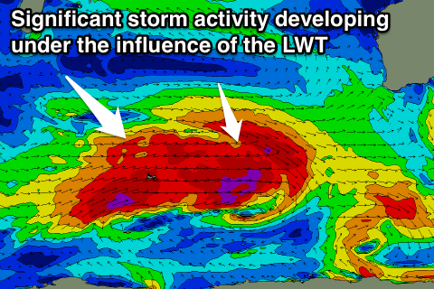
This will be linked to a strong polar frontal progression moving in from the west and with this we'll see a large SW groundswell produced for later Sunday/Monday, followed by a secondary increase Tuesday.
These swells will be generated under the influence of a strong node of the Long Wave Trough developing across the Indian Ocean, with back to back lows due to project broad fetches of severe-gale to storm-force towards us, possibly followed by more activity.
We'll have a closer look at this setup on Wednesday though.

