Only one more week to go
Western Australia Surf Forecast by Craig Brokensha (issued Wednesday 9th August)
Best Days: Keen surfers early Friday around Perth and Mandurah
Recap
Poor small onshore waves yesterday morning, building in size with strengthening onshore winds into the afternoon.
Today a mix of stormy windswell and W/SW groundswell filling in across the state have provided larger 6ft+ waves across the South West, 3-4ft waves around Mandurah and 2-3ft waves in Perth.
Conditions were better in protected spots across the South West with a S/SW breez, while Mandurah and Perth remained a mess.
This week and weekend (Aug 10 - 13)
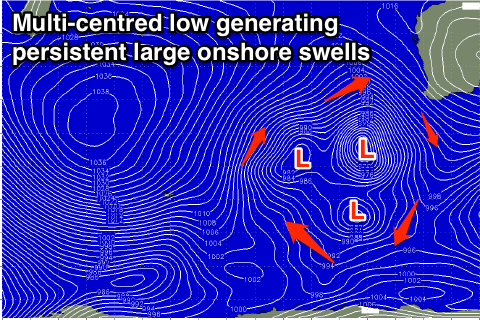
Onshore winds and large swells will continued this period as a broad multi-centred low stalls to our south-west, projecting front after front into us.
Today's mix of W/SW windswell and groundswell should ease off through tomorrow, dropping from 6-8ft in the South West and 3ft to the north as onshore W/SW winds persist, tending W/NW into the afternoon.
Friday's window of early but moderate to fresh N/NE winds around Perth and Mandurah is still on the cards, but the swell will only be small and easing from 1-2ft or so. Margs will offer more size but poor conditions with a strengthening N/NW breeze, kicking up a building windswell across all coasts.
This strong to gale-force pre-frontal NW'ly will be followed by a post-frontal severe-gale W/SW fetch generating a large W/SW groundswell pulse for Saturday afternoon.
 The morning looks undersized but an increase to 8ft is likely through the day across the South West with 3ft waves in Perth and Mandurah. A secondary front approaching from the west will bring strengthening W/NW winds, keeping conditions poor while also bringing with it another larger increase in W/SW swell through Sunday afternoon and Monday.
This will be due to a good fetch of severe-gale W/SW winds being projected towards us by the front, with building surf to 10ft+ due across the South West and 3-4ft in Perth, holding Monday morning.
There'll be no let up in the winds though with a fresh and gusty W/NW tending NW breeze Sunday, with strong N/NW tending W/SW winds Wednesday as another front moves across us.
The broad low should start moving east early-mid next week, but not before one final vigorous frontal system slams into us Tuesday, generating another large stormy increase in swell.
Easing surf is currently expected from Wednesday with onshore winds until about Friday. This looks to finally be the end of our onshore messy surf, but we'll confirm this Friday.


Comments
Enough sand bank formation i just want to surf
hahaha good luck on Friday, not going to happen...
What, this Friday's early N/NE winds, or the S/SE winds next Friday. Fairly confident on both.
Even more confident today regarding the return to offshores late next week as a strong high moves in.
Still don't reckon there'll be banks even after all these shitmixers