Large surf over the weekend, backed up by a larger swell Tuesday
Western Australia Surf Forecast by Craig Brokensha (issued Friday 14th April)
Best Days: Saturday protected spots, Sunday morning, Tuesday north of Margs, Thursday
Recap
Another good day of surf across the South West yesterday with a large increase in SW groundswell and offshore winds, while Mandurah saw fun 2ft sets, but Perth remained tiny until the afternoon.
The swell reached 6-8ft into the afternoon and has held a similar size this morning with a touch less favourable winds from the SE. Mandurah saw great 2-3ft surf, with 1-2ft waves in Perth.
The swell has since eased steadily and winds have gone onshore.
This weekend and next week (Mar 15 – 21)
Tomorrow morning will mark a low point in activity between today's easing swell and a large long-period S/SW groundswell for the afternoon.
The polar low linked to this swell has since weakened, and satellite observations were great with core wind speeds upwards of 50kts recorded.
The swell is expected to build strongly tomorrow afternoon, reaching 6ft to sometimes 8ft across the South West and 2ft later in the day up around Perth, easing back from 5-6ft and 1-2ft respectively Sunday morning.
S/SE winds are expected all day tomorrow, favouring protected spots (more SE through the morning around Perth), while Sunday looks better across the South West with SE-E/SE breezes, reverting back to the S/SE through the afternoon. Monday will be smaller and early S/SE winds are due to swing S/SW.
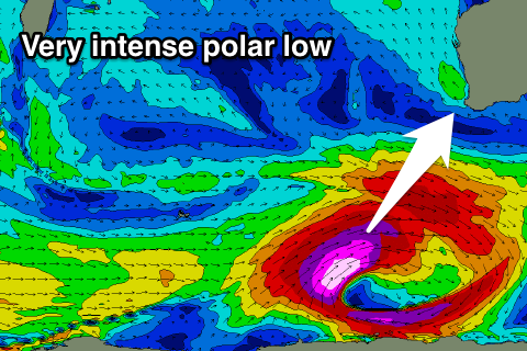
 Our large SW groundswell event for early next week is still on track. Over the coming 48 hours a very intense polar low will form south-east of Heard Island, generating a fetch of pre-frontal gale to severe-gale W/NW winds, followed closely by stronger storm-force W/SW winds.
A very large, powerful and long-period SW groundswell will result, arriving overnight Monday/early Tuesday morning.
The swell will build very rapidly towards a peak through the morning/middle of the day, coming in at 10-12ft+ across the exposed reefs in the South West and 3ft in Mandurah, 2-3ft Perth.
Conditions are looking dicey though with a light to moderate onshore W'ly wind expected across the South West as another approaching front encroaches on the state. Further north we should see more variable breezes though.
This approaching front however will generate another large W/SW groundswell for Thursday hopefully with more favourable and variable winds.
Due to the close proximity we're looking at a consistent swell peaking Thursday to 6-8ft in the South West. We'll have another look at this Monday though. Have a great weekend!

