Large clean swells to come
Western Australia Surf Forecast by Craig Brokensha (issued Friday 24th March)
Best Days: Saturday, Monday protected spots, early Tuesday, Wednesday onwards
Recap
Poor conditions yesterday with a weak S/SW windswell across the South West and Mandurah, a little more surfable around Perth.
Today the swell has eased back across Perth and Mandurah, but a new SW groundswell was showing across Margs, with ok S/SE winds. We should see the long-period energy building through this afternoon and reaching 6ft as winds hold from the S-S/SE.
This weekend and next week (Mar 25 - 31)
This afternoon's building long-period SW groundswell will peak tomorrow to an inconsistent 6-8ft across the South West and 2ft+ in Perth and Mandurah with excellent light offshore E/SE winds.
Winds should remain light into the early afternoon, NW mid-afternoon and fresher into the evening.
This increasing onshore will be linked to a vigorous and deepening mid-latitude which is currently west-southwest of us. This low will project a fetch of W/SW gales towards us, strengthening to the severe-gale range tomorrow before passing across us Sunday.
We'll see a large W/SW groundswell from this low, with building mid-period energy Sunday to 8-10ft late in the day across Margs and 2ft to nearly 3ft in Perth but with strong W/SW tending SW winds.
 A peak in groundswell is due Monday morning to 10-12ft across Margs and 2-3ft in Perth (3ft Mandurah), easing steadily during the day.
Conditions will be clean around Perth with a light E/SE offshore wind, while Margs looks to see S/SE-SE winds ahead of sea breezes.
Tuesday will be half the size with possible variable winds at dawn, increasing from the SW through the day. Perth should be clean with a light offshore wind.
Moving onto Wednesday and our large long-period S/SW groundswell is still on track.
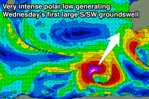
Tomorrow evening a vigorous polar low is forecast to form in the Heard Island region, generating a fetch of severe-gale to storm-force W/SW winds through our southern swell window, which will then draw out up towards The Bight while weakening a touch
We'll then see the polar fetch slingshot back up towards us through our southern swell window Monday and Tuesday, resulting in two large S/SW groundswell events, the first for Wednesday morning and second for later in the day and Thursday morning.
The first for Wednesday should see 8ft+ sets across Margs, 2ft to occasionally 3ft in Perth, while the second looks to be a similar size, holding early Thursday and then easing off steadily into the afternoon, further Friday.
With the secondary projection of gales towards us Tuesday we're now expected to see less favourable S/SE winds Wednesday, but Thursday looks excellent with E'ly offshores ahead of afternoon sea breezes.
Longer term the models are toying with the possibility of another strong polar low forming in our southern swell window mid-week as a tropical depression absorbed into the Southern Ocean storm track, but more on this Monday. Have a great weekend!


Comments
I'll have these notes updated tomorrow (Craig's away for the week). Still looking pretty size on Wednesday though, if anything posisbly a slight upgrade - though the swell direction will be very S/SW which will create a large range in wave heights across the coast.