Average week, better weekend
Western Australia Surf Forecast by Craig Brokensha (issued Monday 6th February)
Best Days: Thursday morning in the South West, Saturday in the South West, Sunday both coasts
Recap
No decent surf at all over the weekend with small to tiny waves and less than ideal winds.
Today cleaner conditions were seen in the South West, but the swell remained really small.
This week (Feb 7 - 10)
Unfortunately this morning was the most size we're expected to see over the coming days with decent conditions.
Tiny to flat surf will develop tomorrow along with onshore S/SW-SW winds.
Our increase in SW windswell for Wednesday and Thursday has been downgraded with just a weak surface trough due to generate a very weak swell.
Wednesday will be very poor with S/SE winds, but a slightly stronger mid-period increase in size is due Thursday, coming in at 3-4ft or so, tiny in Perth.
We're looking at offshore E/SE winds Thursday morning, strengthening from the SE into the afternoon.
Friday will then be small and easing with gusty SE winds.
This weekend onwards (Feb 11 onwards)
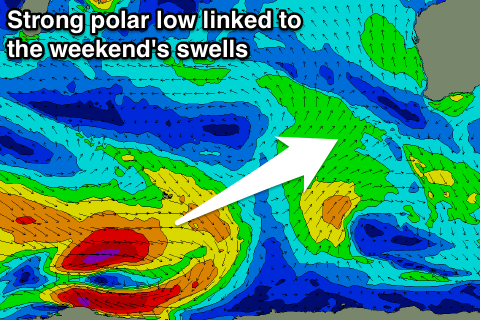
 Some better polar frontal activity is expected in the Heard Island region from this afternoon through the entire week, moving slowly through our south-western and then southern swell windows.
This should generate some fun sized SW tending S/SW groundswell through the weekend, building Saturday to 4-6ft later, and easing from a similar size Sunday morning.
Perth should see inconsistent 1-1.5ft waves into Saturday afternoon, with 1-2ft sets Sunday.
Winds look good as a tropical low/possible cyclone off our north-west drifts slowly south-west directing gusty SE winds on the coast Saturday, more E/SE Sunday.
We'll have a closer look at this Wednesday though.


Comments
Craig - any chance of N/W swell hitting metro area associated with this low?
Keep an eye on the WAMs, but you can see here there is not much of a fetch at all in the swell window..
https://www.swellnet.com/reports/australia/western-australia/margaret-ri...