Easing surf tomorrow, new swell Monday but cleanest Tuesday
Western Australia Surf Forecast by Craig Brokensha (issued Friday 20th January)
Sign up to Swellnet’s newsletter and receive the West Australian Forecaster Notes and latest news sent directly to your inbox. Upon signup you'll also enter the draw to win a surf trip to P-Pass for you and a mate (there's only 1 week left to go). It doesn’t get much easier so click HERE to sign up now.
Best Days: Margs early tomorrow, Perth Monday morning, Margs Tuesday morning, both coasts next Saturday
Recap
Terrible conditions yesterday with a small to tiny swell and gusty onshore wind.
Today though a large new SW groundswell peaked this morning to 6ft+ across the South West with decent winds, 2-3ft around Mandurah and 2ft in Perth. We'll see the swell tail off through the day as sea breezes kick in.
This weekend and next week (Jan 21 – 27)
Today's good SW groundswell will continue to ease through tomorrow and conditions will be a little dicey, with an early S/SE'ly across Margs (E/NE in Perth).
The South West should be easing from 3-5ft, with tiny waves up in Perth. Sunday will then be poor with onshore S/SW winds and small surf, building a little through the day.
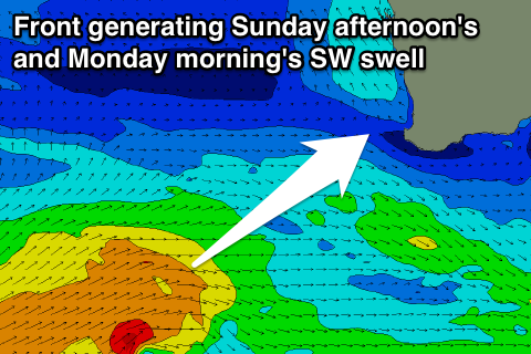
Monday's SW swell (which should build later Sunday) is still looking average, with a relatively weak but persistent polar low currently south-west of us, generating a fetch of strong to sub-gale-force W/SW winds through our south-western swell window.
 This swell should come in at 5-6ft across the South West Monday morning, with 1-2ft sets in Perth, easing off into the afternoon and further Tuesday.
Winds Monday will still be onshore from the S/SW across the South West, while Perth will be a bit better with a morning S/SE'ly.
Tuesday is the day to surf around Margs with an offshore E/SE wind and smaller easing 3-4ft+ waves. Perth will be tiny.
A low point in surf is due Wednesday and Thursday next week with SE-S/SE winds, but later in the week and more so the weekend some better SW groundswell is on the cards.
A slow upwards trend is size is due from Thursday owing to a broad and slow moving polar low from the Heard Island region, towards us most of next week.
Initial post-frontal and pre-frontal winds will generate a small mid-period swell for Thursday, but behind this, stronger W/SW gales spread out over half the southern Indian Ocean should produce a longer-period swell for Friday and Saturday.
At its peak the swell should reach 5-6ft or so on the sets in the South West and 1-2ft in Perth Saturday with what looks to be S/SE winds.
Longer term we might be looking at a larger swell into the next week, more on this Monday. Have a great weekend!

