Large stormy swell to end the week, improving over the weekend
Western Australia Surf Forecast by Craig Brokensha (issued Wednesday 4th January)
Sign up to Swellnet’s newsletter and receive the West Australian Forecaster Notes and latest news sent directly to your inbox. Upon signup you'll also enter the draw to win a surf trip to P-Pass for you and a mate. It doesn’t get much easier so click HERE to sign up now.
Best Days: Saturday morning both coasts, every morning from Sunday in the South West (only 1-1.5ft to the North)
Recap
Clean fun waves across the magnets in the South West yesterday morning, but today there wasn't much left at all with slightly less favourable winds.
This week and weekend (Jan 5 - 8)
The end of this week isn't looking too good at all, with a small lift in new SW groundswell to 3-4ft+ in the South West tomorrow but with an early light onshore wind, freshening through the day from the W/NW.
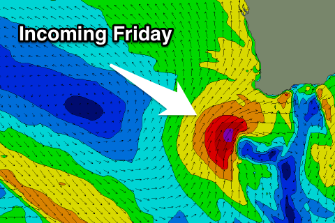
This will be due to an intense mid-latitude low strengthening and approaching from the west, with a tight fetch of SW gales due to be projecting into the South West of the state.
 A stormy increase in SW swell is due, along with strong SW tending S/SW winds, reaching 6-8ft+ in the South West and 2-3ft around Perth.
The low will move off east overnight resulting in a rapid drop in SW swell with a morning S/SE-SE breeze.
The South West should ease from the 6ft range, with 2ft waves around Perth.
Sunday will be smaller again with a better offshore SE wind.
Next week onwards (Jan 9 onwards)
Some fun pulses of SW groundswell are due through next week, the first for Monday morning will be produced by a patchy but persistent polar front moving in from South Africa, generating winds just under the gale-force threshold for most of its lifetime.
A moderate sized SW swell will still result, building Monday to 5-6ft through the afternoon in Margs and 1-1.5ft further north, holding Tuesday.
A secondary front moving in quickly on the tail of the first front should produce a reinforcing and similar sized pulse of swell for later Tuesday and early Wednesday, easing from then on.
Winds will persist from the SE each morning Monday through Tuesday, with a better E'ly offshore Wednesday.
Longer term a slightly bigger SW groundswell is possible Friday, but more on this in the next update.

